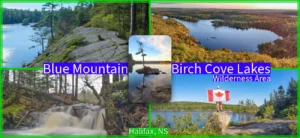
Hobsons Lake Trail, Blue Mountain-Birch Cove Lakes Wilderness
- Difficulty: Moderate – Difficult (rugged terrain & confusing navigation).
- Facilities: None.
- Signage: Unmarked trails with sparse signage.
- Features: 3-hour round-trip 3-lake loop, or less than 1-hour up-and-back to Hobson’s Lake. Scenic cascade waterfall along Hobson Brook. Part of one of North America’s Largest urban wilderness areas.
- Biodiversity: Teaberry, Eastern White Pine, Pileated Woodpecker. View observations on iNaturalist.
Hobsons Lake Loop Trail
 Hobson’s Lake loop trail is a 5.2km loop with direct access to 3 wild lakes: Hobsons Lake, Ash Lake & Fox Lake. There’s a wide array of routes to choose from in Halifax’s Blue Mountain-Birch Cove Lakes Wilderness Area, but amidst the web of trails, this loop is one of the more popular routes. While it’s a great place to hike, good public access points, proper trails, & signage are completely lacking due to its enduring state of purgatory, which has recently escalated to more threats of development. If you don’t want it turned into more urban sprawl, you must stand up for its protection, as Haligonians have for decades.
This hike is best for people with prior wilderness experience. It’s important to come prepared for a rugged hike that requires particular attention to navigation. Cellular phone service can be spotty the further in you go, so you don’t want to rely solely on your phone. Even the short (1-hour) hike from Colins Road to Hobsons Lake and back can be easy to get off track, so don’t take it lightly. I advise starting with a few short hikes to get accustomed to its quirks before you attempt one of the longer routes. Be sure to leave yourself plenty of time before sunset; wrong turns can quickly add up, and you do not want to have to navigate this area in the dark.
These hiking trails are popular for people with dogs, often not leashed. I would highly recommend leashing your dog to keep them safe from coyotes, as well as a courtesy on the more well-used trails. While it’s a fun hike with lots of cool scenery and spots to explore, I don’t recommend bringing children on your first exploration until you have a good feel for it (or stick to the trail along Kearney Lake).
Parking & Access
The best access point for this loop is off of Colins Road. The end of this quiet cul-de-sac has limited parking for 10-15 cars, and can often be overflowing during peak times (good weather weekends). Make sure not to block driveways, keep noise levels to a minimum, and pack out what you take in, as there is no garbage collection beyond a community-maintained bin at the trailhead. Lost items are often hung on the chain link fence here as a de facto lost and found.
Another parking & access point to this area is via a large gravel parking area adjacent to Maskwa Aquatic Club. This land is leased by Maskwa, so please respect that you’re able to park here thanks to them. Their land is leased solely for the purpose of running a paddling club. They do not maintain the trailhead or have any responsibility for people hiking here. Do them a solid by cleaning up after yourself and taking your garbage with you. Do not use Maskwa’s designated parking or block access to their property in any way. The drive into Maskwa passes by a municipal beach and playground. Saskatoon Drive, Like Colins Road, is a quiet neighbourhood with pedestrians & children at play, so keep speeds very low on your way in and out.
Both access points are good starting points to explore this area, so you can opt for one or the other depending on your planned route, or how full each respective spot is (Maskwa has more room). Until this wilderness park comes to fruition, access will continue to be limited. The mess of trails can’t be improved until the park is created from its current patchwork of land ownership, so be sure to keep the pressure on every level of government to fulfill their decades-long promise to create it. The best way to do so is to become a (free) member of the Friends Of Blue Mountain-Birch Cove Lakes Wilderness Society.
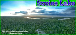
Blue Mountain Birch Cove Lakes Wilderness Area
 There are a couple of small maps posted along the way but the trail is not marked. There are many paths throughout this area so paying attention to where you are going is a must. That being said, it is pretty easy to stay on track if you do so. There are some wilderness area signs, orange marks on trees, footbridges and other trail indicators scattered throughout. The trails are well defined, so you should never be bushwacking or heading into places it seems people haven’t been before you.
The start and end of the trail are uphill and downhill, respectively, but the rest of the trail is less hilly. Granite boulders dominate the area, as well as old-growth trees and moss, giving it a “Lord Of The Rings” feel.
Shop.HalifaxTrails.ca: Gear | Books | GPS | On Sale
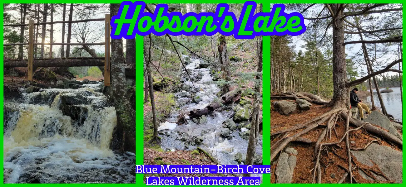
As you reach Hobson’s Lake, the smallest of the 3 lakes, you’ll come to a footbridge. The bridge crosses a small brook leading from the lake and continues toward Kearney Lake. The brook’s waterfall varies in intensity as water levels fluctuate, typically a torrent in Spring, and a trickle in late Summer. Overlooking this area is an elevated granite lookoff with a view of the lake. Reachable with a steep, short climb, it’s worth a visit along the way.
Extended dry spell. Expect reduced water volume.
Algorithm based on 7.6mm of rain and 25°C average highs over the last 96 hours.
Points Of Interest
Ash Lake, the largest of the 3 lakes, is next, and the trail just skims by the head of the lake. There is a great stopping point along the trail at the head of the lake. Be warned that this spot is often accompanied by a stiff wind. The low-lying parts of the trail near Ash lake can be very muddy with tricky footing. Use caution on the slippery logs which lay over some muddy parts. Waterproof hiking boots are often a must.
A short distance later you’ll arrive at Fox Lake, which is an ideal spot to stop to recharge. There are a couple of different paths leading to Fox Lake, so pay attention to where you’re headed, and aim for the granite shoreline.
The last leg of the trip connects to the Fox Lake trail, and from there you can head a few different ways (see map). If you’re headed to Colins Rd, it’s fairly simple to get back if you just stay to the left.
The trail is one of the most beautiful, untouched nature trails in Halifax in my opinion. Though it can be an easy hike done in less than an hour (up & back to Hobsons Lake), it’s not a trail for beginners. The rugged terrain and navigation issues aren’t something you want to jump into without prior experience on similar wilderness trails. Bugs can be bad in Spring, so prepare accordingly and always check for ticks anytime temperatures are above zero.
My Hobsons Lake Photos