- Difficulty: Easy (distance dependent) 32km stretch of the 123km Rum Runners Trail.
- Facilities: Parking. Outhouses at nearby parks. Bike repair & rentals at Bike & Bean (East end) and Scotia Cycle (West end).
- Signage: Maps and info at major trailhead access points. Some historical and nature interpretive signage.
- Features: Well-maintained, hard-packed crusher dust surface. Shared-use with pedestrians, cyclists, ATVs & horseback. Access to public parks and beaches along the route.
- Biodiversity: A vibrant edge ecosystem, showcasing everything from towering Red Spruce and delicate Painted Trilliums to diving Ospreys and foraging North American Porcupines. View the Nature section below.
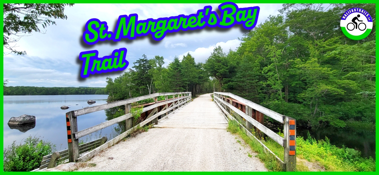
The St. Margaret’s Bay Trail

- Heading East: It transitions seamlessly into the BLT Trail (taking you back toward Halifax).
- Heading West: It transitions into the Aspotogan Trail (taking you toward Chester and Lunenburg).
Trailheads & Where To Park
Because the trail is a linear 32 km point-to-point route, choosing the right starting point is crucial. Here are the three main access points with dedicated parking:
Hubley Trailhead (The Eastern Start)
Location: Pull-off parking area off St. Margaret’s Bay Road (Highway 3), Hubley.
This is the official eastern terminus of the St. Margaret’s Bay Trail, right where the BLT Trail ends. It features a small parking area directly off the highway with space for 5-6 cars. Note: You will need to cross a busy section of St. Margaret’s Bay Road to access the BLT Trail from this parking lot. There is no marked crosswalk here, so use extreme caution, especially if you have children.
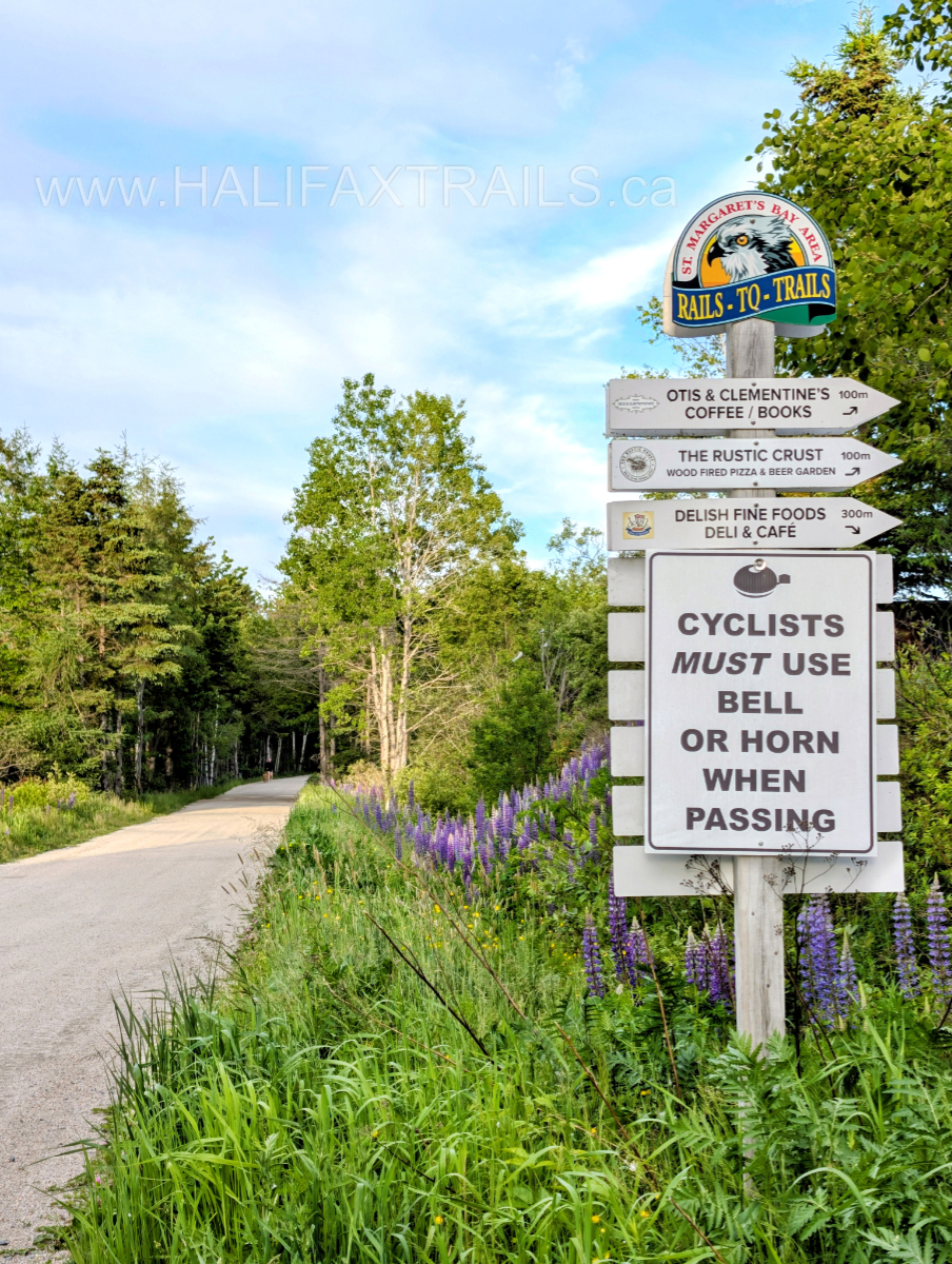
French Village Station / Bike & Bean (The Hub)
Location: 5210 St. Margaret’s Bay Road, Tantallon.
This is arguably the most popular staging area for cyclists. Located roughly 5 km into the trail, you’ll find a large parking lot behind a shopping plaza, situated near the Bike & Bean Cafe. Housed in the historic 1887 French Village Train Station, this is the perfect spot to grab a coffee, pick up a rental bike, or borrow some tools for a quick tune-up before hitting the trail.
Hubbards Trailhead (The Western End)
Location: Station Road, Hubbards.
If you prefer to start your journey on the coast and head inland, the Hubbards access point is your best bet. Located near the end of the trail, parking here puts you in close proximity to the community’s local restaurants, accommodations, and the nearby Queensland and Cleveland beaches. Free bike borrowing and (paid) Level 3 EV charging are available nearby at the JD Shatford Memorial Library. Bike rentals & repairs are also available at Scotia Cycle in Hubbards. From here, the trail connects seamlessly to the Aspotogan Trail heading further down the South Shore.
Trail Conditions & Multi-Use Rules
Because the St. Margaret’s Bay Trail is built on a decommissioned railway line, it offers a predictable, accessible experience for most ages and skill levels. However, recent changes to the landscape and its status as a shared multi-use corridor mean you need to come prepared.
The Surface: Fast, Flat Crusher Dust
The trail features a very flat grade and a firmly packed crusher-dust surface.
- For Cyclists: It is a dream for gravel, hybrid, and mountain bikes. While you can ride a road bike on it, the loose gravel patches and occasional washboarding make wider tires a much more comfortable choice.
- For Walkers: The smooth surface is highly accessible for strollers and mobility aids, though keep in mind the distances between amenities are vast.
Recent Widening & Sun Exposure
If you haven’t been on the trail in a few years, you will notice a major difference. Extensive trail maintenance and brushing efforts have significantly widened the corridor. While this creates excellent, safe sightlines, it has removed some of the tree canopy that used to shade the path.
- Summer Planning: You are now exposed to direct sunlight for long stretches. Pack extra water, wear sunscreen, and bring a hat, as the “tunnel of trees” effect has been reduced.
- Winter & Shoulder Seasons: The open corridor acts as a bit of a wind tunnel, blowing right off St. Margaret’s Bay. A good windbreaker is essential.
ATV Etiquette & Sharing the Trail
The St. Margaret’s Bay Trail is a multi-use route, and local ATV clubs play a role in funding and maintaining the smooth surface you get to enjoy. You will be sharing the path with ATVs, dirt bikes, and side-by-sides. Use extra caution where the trail crosses Bowater Mersey Road, as it’s a busy corridor for ATVs coming & going into the Bowater Trails.
To keep the trail safe and enjoyable for everyone, follow this etiquette:
- Use A Bike Bell: Alert others when passing from behind. Helmets are required, but bike bells should be, too.
- Keep to the right: Treat the trail like a two-lane road. Always walk or ride on the right-hand side, especially on blind corners.
- Ditch the noise-cancelling headphones: You need to be able to hear motorized vehicles and bike bells approaching from behind. If you want to listen to music, keep one earbud out.
- Manage your pets and kids: If you hear an engine approaching, call your dog to heel (they must be on a leash) and ensure children step to the right edge of the trail.
- Be courteous: Most ATV riders are incredibly respectful and will slow well below the 20km/h speed limit to minimize dust as they pass. A friendly wave goes a long way in maintaining a good multi-use trail culture.
- Horseback: All users must yield to horses. If you meet one, slow down, ring your bell if passing from behind, and be prepared to stop. Pass slow & wide.
Parks & Coastal Beaches
As you navigate the trail, you will encounter some of the South Shore’s most prized coastal getaways. These make perfect mid-ride breaks or full-day destinations.
- Cleveland Beach Provincial Park: A scenic, compact public sand beach. It is easily accessible from the trail, but the parking lot fills up quickly on warm summer days. Pack a lightweight, quick-dry microfibre towel in your saddlebag for a spontaneous dip.
- Queensland Beach: Located just 3km further west, this is one of the most popular summer destinations for Halifax locals. The white sand and clear waters are unmatched, but expect bustling crowds during peak season.
St. Margaret’s Bay Trail Photos


Hubbards: Your Coastal Basecamp
The western end of the St. Margarets Bay Trail anchors in the beautiful coastal community of Hubbards. It is an ideal spot to jump off the trail for local eats, refreshments, and down-home entertainment.
If you are planning a multi-day ride or want to extend your trip, Hubbards is the perfect place to stay overnight. It’s also EV-friendly, making it easy to top up at the local Level 3 charger at JD Shatford Memorial Library before heading back.
Plan Your Stay: Check out Hubbard’s Beach Campground & Cottages or browse this interactive map to find cozy coastal cottages, bed & breakfasts, and local accommodations right near the trailhead.
Eat, Drink & Be Merry – Local Faves:
- The Trellis Cafe: A quintessential South Shore landmark since 1985. It’s an ideal spot right in Hubbards to stop for a fresh coffee, a hearty breakfast, or their signature seafood chowder.
- The Tuna Blue: Located right on the water in Hubbards, offering fantastic marina views from their Beer Garden. It’s the perfect place to relax on the patio with fish tacos, a great burger, and a cold drink.
- Shore Club: A true Nova Scotian institution. If you are wrapping up your ride later in the day (Wednesday through Sunday from May to October), you can treat yourself to their world-famous, traditional lobster supper.
- Sheila’s Canteen: If you are looking for a quick, satisfying post-ride take-out meal, this seasonal food truck has been serving up maritime soul food since 1991.
St. Margarets Bay Views & Highlights
The Eastern end of the passes serene lakes, while hugging rivers & streams on the way toward St. Margaret’s Bay. The Western end of the trail winds its way adjacent to St. Margarets Bay Road, utilizing the elevated grade of the old railway to offer sweeping, panoramic views of the water below. While there are plenty of trailside hidden beauties (marked on my trail map), there are a few standout stops to consider.
- Jerry Lawrence Provincial Park: Accessible directly from the trail, this is your premier rest stop. It features covered picnic areas, accessible fishing piers, and plenty of space to relax under the Acadian forest canopy.
- The Bike & Bean: A legendary stop for trail users. Housed in a historic train station, it’s the ultimate spot to grab a coffee, refuel with a bite to eat, or browse their bike shop for last-minute gear.
- Bay Lookout Park: Offering some of the most unobstructed, expansive views of the bay. It’s a fantastic spot with various picnic areas and access to a public wharf. A short distance from the trail, but be mindful when crossing St. Margaret’s Bay Rd. as vehicles travel at high speeds.
Rivers, Bridges, and Coastal Microclimates
 While the trail features a few rolling sections, the grade is very manageable. The route crosses several historic, elevated railway bridges, perfect spots to take in scenic views of the rivers running from the hilly slopes down into the bay.
A quick tip on the weather: The invigorating coastal climate means you are exposed to the open breezes coming off the Atlantic. Temperatures can easily drop a few degrees Celsius compared to the inland sections of the trail, and the weather shifts quickly. It’s wise to have a packable, windproof jacket so you aren’t caught off guard by the ocean chill.
Nature & Wildlife
The St. Margaret’s Bay Trail offers a stunning corridor where the dense Acadian forest meets the salty breezes of the Atlantic. As the path winds past coastal coves, salt marshes, and river estuaries, such as the scenic crossing over the Ingram River, it highlights a diverse botanical landscape. The inland side of the trail is sheltered by a robust canopy of Eastern White Pines, Balsam Fir, and Red Spruce. In the damp understory and boggy pockets bordering the trail, hikers and cyclists can easily spot Cinnamon Ferns, vibrant patches of moss, and delicate seasonal blooms like the Painted Trillium and Pink Lady’s Slipper and rows of Lupin.
Because the trail acts as a natural border between the woods and the water, it is a spectacular route for wildlife watching, particularly for birders. The shallow coastal inlets and river mouths are prime hunting grounds for coastal birds; it is very common to spot Ospreys plunging for fish, Bald Eagles soaring high above the tree line, and Belted Kingfishers darting along the river banks. In the quieter, marsh-filled ditches alongside the path, you might spot Painted Turtles basking on half-submerged logs or hear the trill of Spring Peepers. The protective tree line also shelters plenty of terrestrial wildlife, making it easy to spot White-tailed Deer, busy American Red Squirrels, and the occasional North American Porcupine ambling through the adjacent brush. View and record St. Margaret’s Bay Trail observations on iNaturalist.
Trip Tips
Local Eats & Refreshments
No trail day is complete without a great post-ride meal. The St. Margarets Bay area has some fantastic local hot spots to refuel at:
- The Bike & Bean (Tantallon): The perfect mid-ride coffee stop right on the trail.
- Hubbards Hot Spots: Once you hit the western terminus, treat yourself to a massive coastal meal or local bakery treats at establishments right near the trailhead.
- Trailside Picnics: If you prefer to eat on the route, grab some flavorful takeout or shop for food in Upper Tantallon on the Eastern end or Hubbards on the Western end. The covered picnic table on Round Lake makes a perfect place for a quick lunch, or head directly into Jerry Lawrence Provincial Park for longer enjoyment.
Family Adventures
If you’re looking for a fun, family-friendly outdoor adventure to complete with the kids, try “Brother Nature’s Riddles” to outsmart the trickster, Brother Nature. The step-by-step instructions for this 2.3 km (return) trail adventure and a route map can be downloaded at earthadventures.ca. The approximate time to complete the adventure is 2 hours.
Trail Updates & Support
For the latest news, conditions, and updates on the trail, visit the St. Margaret’s Bay Area Rails To Trails Association’s Facebook page. The trail relies heavily on community support, so consider becoming a member of the St. Margaret’s Bay Trails Association to contribute to their ongoing maintenance and improvement efforts.
Turn It Into A Coastal Getaway
Why rush back to the city? The South Shore is meant to be savoured. Use this interactive map to find the best local accommodations, from cozy seaside cottages to modern bed & breakfasts, just minutes from the trailheads or book a campsite at Hubbards Beach.
Gear Up For The Coast
Before you head out, make sure your kit is dialled in. Because the coastal sections of the trail are exposed to the sun and salty breezes, pack plenty of water. Always have an extra layer or two for warmth, wind & rain protection as coastal weather changes rapidly. Check out my curated shop for outdoor gear & local guidebooks.
Gear Up & Support Local Purchases help fund these free, independent guides.![]() Books | Gear | On Sale
Books | Gear | On Sale

Coleman Screened Canopy Tent with Instant Setup, 11x11ft Portable Screen Shelter with 1-Minute Setup for Bug-Free Lounging, G...
🚴♂️The St. Margaret's Bay Trail is 32km of riverside & seaside rails-to-trails with access to parks, beaches, and cafes along the way.
📍Check out my full guide for parking, highlights, 360° views and trip tips:

St. Margaret’s Bay: NS’s Scenic Coastal Rail-Trail Escape 🚲🌊
Ride the bay! 🚲 Maps, 360° tour & parking tips for the St. Margaret's Bay Trail. 33km of flat, scenic wood...
www.halifaxtrails.ca