
Long Lake Provincial Park
- Difficulty: Easy to difficult (distance/terrain/navigation), route dependent.
- Facilities: 3 parking lots, Dry bathroom, paddling launch & rentals.
- Signage: Minimal. Mostly along the Lakeview Trail.
- Features: 2,000-hectare wilderness park. Accessible 5km Lakeview Trail loop, rugged wilderness hiking paths, and a dedicated open-water swimming course.
- Biodiversity: A vibrant hub for wildlife where Ducks, Garter Snakes, and Toads flourish alongside a lush canopy of Red Spruce and Red Maple (view the Nature section below).
- Trail Conditions: View & sign the logbook for updates from fellow explorers.
Long Lake Provincial Park
Just a 15-minute drive from downtown Halifax, Long Lake Provincial Park offers a scale of untamed wilderness you rarely find inside city limits. The park’s massive footprint is defined by striking geology, expansive lakeside look-offs, and an ecosystem wild enough to support beaver dams, towering old-growth trees, and wildlife you wouldn’t expect to see inside city limits.
Thanks to recent accessibility upgrades, Long Lake has transformed into the city’s premier hub for outdoor recreation. It shares the lively, communal vibe of Point Pleasant or Shubie Park, but its sheer size means you can always find a quiet corner to call your own. Whether you’re launching a kayak, bringing the stroller for an easy loop, or bushwhacking through unmaintained singletrack wilderness trails, Long Lake is the ultimate backyard escape.
Parking Lots & Access Points
Long Lake is incredibly popular, and space can be severely limited at all lots during peak summer weekends. If you are meeting a large group, definitely try to carpool. Security Warning: Unfortunately, “smash and grab” break-ins are a known issue at all Long Lake parking areas. Never leave valuables in your car, and make sure any bags or items are completely hidden before locking your vehicle. While there are several neighbourhood access points (which I have marked on the interactive map), there are three primary parking lots:
1. Main Entrance (Dunbrack Street)
This is the largest and most popular parking lot, serving as the primary trailhead for the paved Lakeview Trail.
- Capacity: 40–50 cars (still fills up quickly on summer weekends).
- Facilities: Seasonally serviced toilet, park map, and trail information kiosk.
- Winter Access: The main gate is closed from mid-October until Easter weekend. You can park in the small area in front of the gate during the off-season, but do not block the gate.
2. St. Margaret’s Bay Road Lot
The second-most-popular entry point, offering access to the quieter northern trails.
- Capacity: ~20 cars.
- Overflow: Cars often fill every inch of the road shoulder here. You can use a nearby carpool lot as a last resort, but be warned: it requires a sketchy 400-meter walk along a very busy road with no sidewalks (only a painted bike lane).
- Winter Access: The lot is not gated in the winter, but it is rarely plowed or maintained.
3. Paddling Launch (Old Sambro Road)
This lot is specifically intended for water access and is where the on-site rentals are located.
- Capacity: Extremely limited. It is the hardest lot to get a spot in during peak times.
- Drop-offs: There are a couple of spots reserved strictly for 15-minute unloading, allowing you to drop your boat before hunting for a permanent spot.
- Winter Access: Gated off and completely unusable in the off-season.
Skip the Parking: Getting To Long Lake By Bus
When the summer crowds hit, and the main parking lots are full, Halifax Transit is your best alternative. Long Lake Provincial Park stands out as one of the city’s best public transit accessible outdoor destinations, letting you jump straight from a city bus into rugged wilderness with several routes dropping you at or near the major access points. If you’re heading for the wilderness trails, Route 22 drops you right near the St. Margarets Bay Road entrance.
There are no bus routes that travel to the Dunbrack Street main parking lot. Instead, transit riders should head to the access points directly across from the Long Lake Village subdivision. Route 22 (Armdale) and Route 127 (Cowie Hill Express): Your best option for reaching the Lakeview Trail. Get off at the stops along Tamarack Drive, a 5-minute walk to the Dunbrack intersection access point.
Over on the Spryfield side, the Route 24 drops you near the Dentith Road dam, where you can immediately hop onto the wilderness trails on the lake’s western shore. Finally, if you’re carrying gear to the paddling launch at the Old Sambro Road entrance, Route 127 Express drops you right at the boat launch.
Skipping the parking hassle completely means you can spend more time on the water and less time circling for a spot. See detailed routes and schedules on the Halifax Transit website.
Kayaking, Canoeing & Paddleboarding
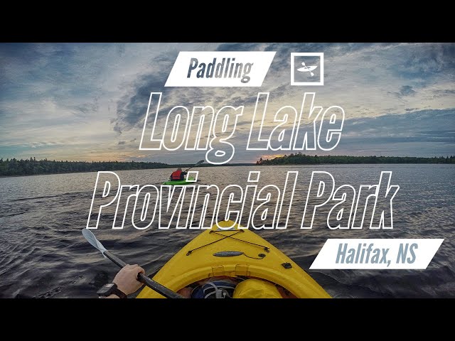
- Rentals: If you don’t have your own boat, Long Lake Adventure Company operates a kiosk right at the launch, offering kayak and paddleboard rentals from early June to late September.
- The Launch Lot: As mentioned in the parking section, this lot fills up fast and doubles as a busy swimming spot on hot days. Utilize the two 15-minute drop-off spots to unload your gear before hunting for parking.
Destinations & Distances
- Goat Island (1 km / 20–30 min one-way): The smaller of the lake’s two main islands is a popular paddling destination. It features sandy patches, large rock formations, and a sheltered center. Because Long Lake gets many visitors but little funding, please do a good deed and pick up litter if it’s safe to do so.
- Full Lake Traverse (3.5 km / 1.5 hrs one-way): Paddling the lake from end to end is a 7 km return trip. In good conditions, expect a relaxed round trip to take around 3 hours.
⚠️ Wind & Weather Warning
Long Lake can get surprisingly windy, and the long stretch of water from the launch point to Goat Island is open and exposed. When departing from the Old Sambro Road launch, expect a headwind. Always keep in mind that the weather can shift with little warning while you are out on the water. Tip: Plan your paddle for the morning or evening when conditions are typically the calmest.
Swimming at Long Lake: What to Expect

Long Lake is one of Halifax’s most popular summer swimming holes, but it remains a rugged, unsupervised environment. Because it is a provincial park rather than a municipal beach, there are no lifeguards on duty and no official water quality testing. It is strictly swim-at-your-own-risk.
Halifax’s lakes have been plagued by dangerous cyanobacteria from blue-green algae blooms that are becoming more frequent. This lake used to be part of the city’s water supply until the mid-1970s, so its water quality was spared from the increasingly ill-considered urban sprawl that has endangered other watersheds.
Buoys mark an open water swim course. This marked grid provides courses ranging from 1 to 2.5km (see map). The course spans from the paddling launch area near the dam at Old Sambro Rd. end of the lake, to Goat Island near the middle of the lake. Play it safe by using a lifejacket or swim buoy.
Algorithm based on thermal lag and seasonal averages.
Finding the Best Spots
Skip the shallow, reedy areas near the main parking lots. The best places to swim are the deep, granite outcrops situated along the Lakeview Trail, Old Sambro Road paddling launch and areas adjacent to the Pipeline Trail. These rocky ledges act as natural docks, offering clean entry points into deeper water and plenty of space to sunbathe. The open water swim course is best accessed from the paddling launch or at the other end of the dam (no parking nearby).
Field-Tested Tips
- Wear water shoes: The lake bottom is notoriously rocky and slippery. Water shoes will protect your feet from sharp rocks, broken glass, and leeches.
- Avoid the leeches: Leeches are common in the warm, shallow, and stagnant sections of the lake. Sticking to the deeper water and rocky ledges minimizes your chances of encountering them.
- Pack it out: There are no garbage cans once you leave the trailhead. Bring a dry bag for your wet gear and pack out all your trash.
Long Lake Provincial Park Photos


Hiking & Biking Trails at Long Lake
The Lakeview Trail
Distance: 3.5km loop | Time: ~1 hour | Difficulty: Easy / Accessible
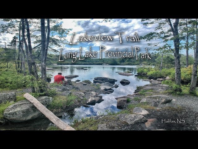
- Getting There: Park at the Dunbrack Street lot. A 600m linear path connects the lot to the main loop. You can also access the trail easily on foot or by bike from the Stanley Park/Dunbrack Street intersection.
- What to Expect: There are no significant hills, just small dips and inclines. Expect about an hour of walking or 30 minutes of cycling. Benches are placed every 200m (or less), providing plenty of resting spots.
- Points of Interest: Heading right from the parking lot, look for well-travelled footpaths leading to scenic vantage points along Witherod Lake. One access point brings you directly to the Long Lake shoreline, complete with a bike rack if you want to stop for a swim.
Trail Etiquette: This wide trail accommodates walkers, joggers, and cyclists, but it experiences extremely high traffic during peak hours, similar to Point Pleasant Park. If cycling, aim for off-peak times, keep right, and always use your bell before passing. Dogs must remain on-leash.
The Pipeline Trail Loop
Distance: 3km | Time: 1–2 hours | Difficulty: Rugged / Unmaintained
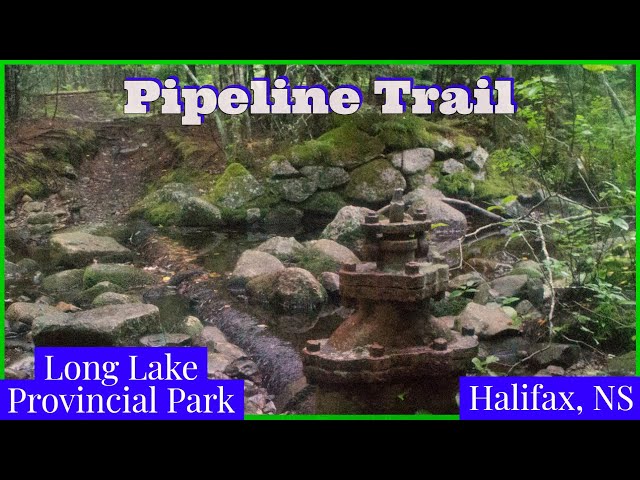
- Getting There: Accessed via the parking area off St. Margaret’s Bay Road. Note: This lot fills up quickly. Fortunately, there is a nearby bus stop on route 22.
- Essential Gear: Waterproof hiking boots are recommended year-round to keep your feet protected & dry. In winter and early spring, traction spikes are highly recommended to prevent slips on the ice. Bug spray is a must in early summer.
- Dog Rules: This is a strict on-leash area. Pack out all waste and consider bringing an empty peanut butter container or a bag holder to store used bags to deposit them in the lone garbage can next to the parking lot. Practice Leave No Trace principles.
Navigating the Pipeline Loop (Counter-Clockwise)

Starting from the lake near the parking lot, head right. The trail is rough and eroding. After 800m, you will enter a dense forest and eventually spot a large, rusty valve from the old pipeline near a babbling brook which crosses the trail.
⚠️ Critical Turn: Just before the trail meets the brook, there is a 90-degree left-hand turn that loops down toward the lake. Do not miss this turn. If you cross the river and continue straight, the trail eventually disappears into dense brush 4km away near Spruce Hill Lake.
After making the correct left turn, the trail narrows significantly. Please stay on the established path to prevent further soil erosion.
Along this stretch, you’ll find a storybook-like cascade with a memorial bench, a rickety footbridge (use at your own risk), and a massive old-growth hemlock leaning over the river. The final 500m follows the Long Lake shoreline back to the parking lot. Give yourself at least 2 hours before sunset; navigating this unmarked trail in the dark is incredibly difficult.
Cranberry Pond & Unmarked Wilderness Trails
Distance: 2km loop (up to 9km of connecting trails) | Time: 40+ mins | Difficulty: Challenging (Rugged / Unmarked)
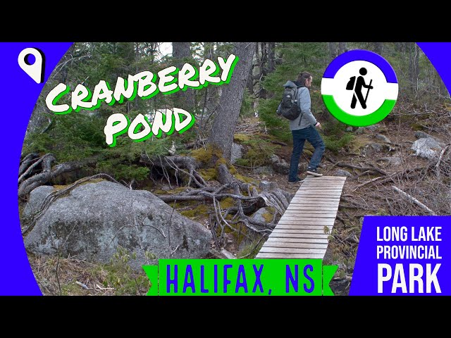
⚠️ Parking & Safety Warning: Dunbrack Street Shoulder. The most direct access is a trailhead off Dunbrack Street, where cars often park on the shoulder. Space is extremely limited, and pulling in or out next to high-speed traffic is dangerous. It is absolutely not safe for small children or off-leash pets. Safer Alternative: Park at the main Dunbrack Street lot or St. Margaret’s Bay Road and access Cranberry Pond via the Lakeview trail, which will add a few extra kilometers to your hike.
What to Expect on the Trail
The shortest loop around the pond is 2km and takes roughly 40 minutes, but you can spend hours exploring the additional 7km of adjoining paths.
- Terrain & Navigation: There is zero signage, and the paths are rocky, rugged, and frequently muddy. Because of the confusing forks, it is highly recommended to come prepared and allow plenty of time before sunset. Sturdy, waterproof hiking footwear is non-negotiable here.
- Birdwatching & Wildlife: Half of the pond is a biodiverse wetland marsh. It is a fantastic spot to sit and observe, as Ospreys heavily frequent the area.
- The West End Crossing: At the far end of the lake, the trail traverses a steep decline to reach a narrow water crossing. There is an old wooden bridge you can use at your own risk, or you can cross the adjacent rocks if the water levels are low enough.
As you complete the second half of the loop, keep an eye out for a massive old-growth white pine tree and several scenic vantage points overlooking the marsh. Pay close attention to your footing and direction, as this side of the pond gets exceptionally muddy and the side trails can be disorienting.
Remote History: Old Coach Road & Scar Road
Distance: Variable | Time: 1–3+ hours | Difficulty: Challenging (Unmaintained Wilderness)

- Scar Road: Dating back to the era when Long Lake served as Halifax’s water supply (which ended in 1980), this road was never completed. Today, it cuts a deep, rugged “scar” down the middle of the park’s landmass, with old dams and waterworks still visible along the route.
- Old Coach Road: Predating the 1800s, this historic route hides hints of an early farm settlement. (Tip: To fully appreciate the history here, the Five Bridges Wilderness Heritage Trust provides a fantastic free walking guide you can read to help with your planning.
⚠️ Wilderness Safety & Navigation Warning: These trails are entirely unmarked and should not be attempted by inexperienced hikers. The paths branch in multiple directions, often dead-ending in remote wilderness. Depending on recent weather, expect sections of heavy flooding, deep mud, and highly unpredictable terrain.
Getting There & Preparation
Both trails are accessible via Old Sambro Road, via a small pull-off area at the trailhead.
Because nature has reclaimed much of these backroads, you need to treat this as a true backcountry hike. Prior wilderness experience is highly recommended. Never rely solely on a cellular connection out here; ensure you have offline GPS & printed maps, plenty of water, and essential safety items before heading out.
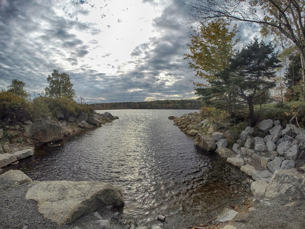
Old Sambro Road Dam & Western Shoreline
Distance: 350m + | Time: 30 minutes to 3 hours | Difficulty: Easy – Difficult (hazardous dam areas & unmarked wilderness trails)

- Sunset Views: The scenic sitting area at this end of the lake is one of the best spots to watch a summer sunset over the water. If you plan to stay late to catch the golden hour, make sure to pack a headlamp so you can safely navigate back to the main roads in the dark.
- Access & Parking Challenges: Getting to this specific spot requires some planning. The best access to the far end of the dam and the scenic paths along the lake’s western shoreline is via a gated gravel pathway off Old Sambro Road. However, there is no parking nearby. You will need to walk, bike, or get dropped off to use this access point safely.
⚠️ Safety Warning: The Spillway. While the dam itself is fascinating to walk along, the area immediately surrounding the spillway is dangerous and difficult to navigate. Not a good spot for children and pets; stay back from the steep drops, and avoid the slippery concrete sections near the water flow.
Nature & Wildlife
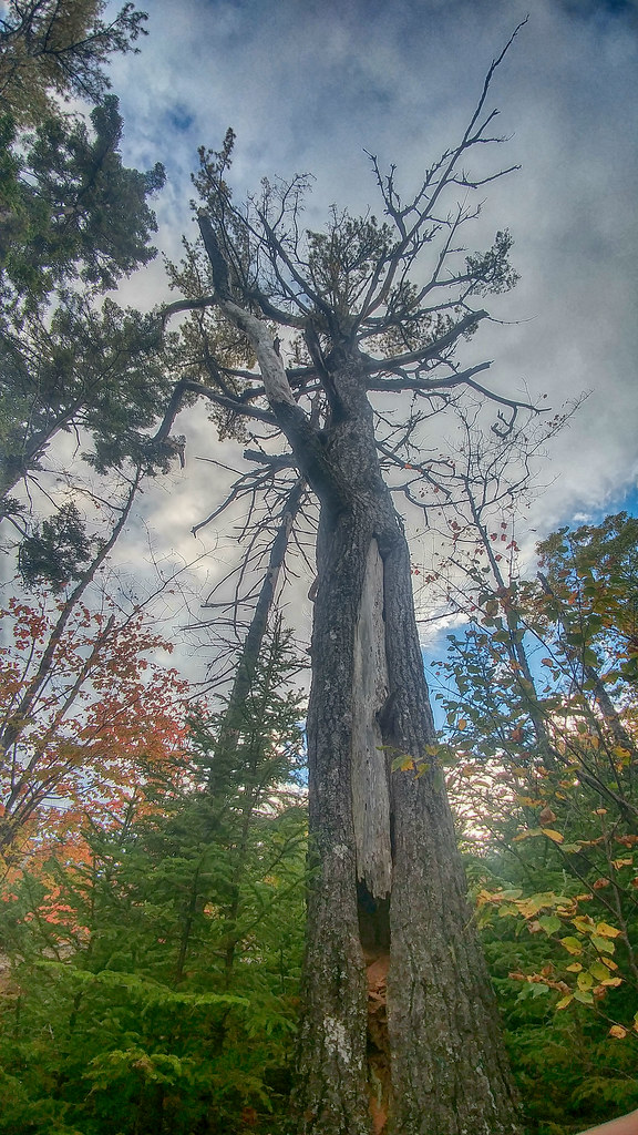
Long Lake Provincial Park is a haven of biodiversity, where hundreds of documented species create a thriving ecosystem just minutes from downtown Halifax. Beneath a canopy of Red Spruce and Red Maple, the forest floor is alive with native plants like the delicate Pink Lady’s Slipper, Canadian Bunchberry, and Trailing Arbutus. This rich habitat supports a diverse array of wildlife, providing a vital sanctuary for both common and specialized species to flourish in a protected natural setting. The park’s specialized residents reward the keen observer, such as the Purple Pitcher Plant, a carnivorous plant adapted to nutrient-poor bogs, and Ghost Pipe, a unique, translucent white plant that lacks chlorophyll and derives nutrients from fungi.
The park’s waters and woodlands are equally bustling with activity, offering frequent sightings of local fauna. You might spot a family of American Black Ducks paddling on the lake, catch a glimpse of an American Red Squirrel darting through the trees, hear a Toad or be startled by a harmless Garter Snake along the trail. Whether you are interested in birdwatching, herping, or simply appreciating the local flora, the park serves as an accessible gateway to Halifax’s vibrant natural life.
Recent Community Sightings
Live wildlife and plant observations logged along this route:


Spot something interesting while out on the trail?
View & Log SightingsTrip Tips
For park news & announcements, check the Long Lake Provincial Park’s community group Facebook page.
Want to turn your visit into a getaway? Find the best accommodations and unique stays just minutes from the park with this map.
SEASONAL CONSIDERATIONS
- Bugs & Ticks: Bug spray is essential in May and June. Ticks are a reality across Nova Scotia and are active anytime temperatures are above freezing (0°C). Make regular tick checks a post-hike habit to avoid them, and gear up with some bug protection.
- Winter Access: The park has no winter maintenance, meaning there is no plowed parking, cleared trails, or garbage service. The main parking lot gate on Dunbrack Street and the paddling launch on Old Sambro Road are closed for the season. The parking lot off of St. Margaret’s Bay Road is open during winter, but there is no snow clearing or garbage removal. You can park before the gate on Dunbrack Street, but do not block it. If you venture out, ice cleats are highly recommended.
PARK ETIQUETTE & RULES
- Pack Out Your Trash: Long Lake is for day use only (no camping or open fires). Garbage collection is sparse, and there is no potable water on-site, so bring what you need, pack it out with you and follow Leave No Trace outdoor ethics.
- Dogs Must Be On-Leash: The trails off St. Margaret’s Bay Road are no longer off-leash. Please respect the rules to avoid fines. Bring a bag holder and pack out your used poop bags.
HIKING & BIKING
- Biking: The Lakeview Trail is highly trafficked. Stick to off-peak times (like weekday mornings), stay to the right, and use a bicycle bell. Venturing off this trail is for experienced mountain bikers only. A helmet and bicycle bell are must-haves for all of our local trails.
- Hiking: Unmarked wilderness trails dominate the rest of the park. Do not explore these rugged areas without proper footwear, safety equipment, and a solid grasp of backcountry navigation. Always tell someone your plans.
NEARBY LOCAL FOOD & REFRESHMENTS
If you’re looking to fuel up before hitting the trails or grab a post-hike bite, check out these independent local favourites nearby:
- Station Six (Spryfield): Located just down Herring Cove Road, this modern-rustic spot is inspired by the nearby fire station. It’s an excellent stop for high-quality pub fare, cold drinks, and patio seating.
- 5K Cafe & 3 Mile Outfitters (Bayers Lake): Found on Chain Lake Drive, this is a fantastic hub for outdoor enthusiasts. Grab an espresso or a healthy sandwich, and browse their outdoor gear selection. Conveniently located right next to the Chain of Lakes Trail.
- PAVIA Gallery ~ Espresso Bar & Café (Herring Cove): A short drive from the park, this beautiful cafe blends contemporary fine art with authentic Italian espresso, grilled panini, and fresh baked goods. It’s also close to beautiful Herring Cove Provincial Park.
- Mezza Lebanese Kitchen (Spryfield): If you want a quick, healthy takeout option to eat lakeside, Mezza on Herring Cove Road serves up excellent made-to-order shawarma wraps and protein bowls.

Featured Products
Purchases help fund these guides