Webber Lake Falls Hiking Trails
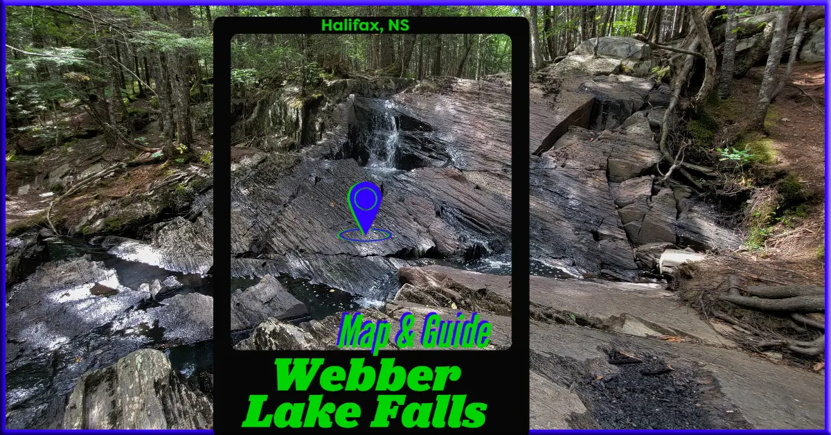
Webber Lake Falls stretch for about 20ft, producing more of a cascade effect rather than a big dramatic drop-off. It’s a scenic spot with more than just the waterfall to enjoy. The trails are rich in forest-bathing scenery, complete with large trees, brooks & interesting geologic features at the falls. Your outing can be a short half-hour trip to the waterfall, or well over an hour if you want to explore more of the area. I recommend allowing at least one hour to fully enjoy it.
In keeping with my unintentional record for waterfall visitation, I explored Webber Lake falls during the dryest time of the year (August). My photos & videos won’t do the waterfall justice, but you’ll be able to see some better, more recent photos shared by others on this page under the heading “Share Your Adventure” below. For the best waterfall experience, visit in early spring, late fall, or early winter.
Parking & Access Points
 There are 4 possible entry points, but for my visit I entered via the service road off of Lucasville Road. This seems to be the most common method of access. This dirt & gravel service road is for a Nova Scotia Power transmission station and its very poorly maintained with lots of bumps. From Lucasville Road, you drive up the service road for 400m until you reach concrete barricades adjacent to the high-power transmission lines.
Cars that are low to the ground will need to go especially slow to avoid bottoming out. That being said there were numerous sedans at the parking area when I arrived. If you don’t want to chance the bumpy road, you can park near the service rd. entrance but be careful not to block the road or access to the community mailboxes. Stick to parking on the same side of the road as others when possible.
Another access point is the other end of the service road from Margeson Drive. This section of the access road is in even worse condition, where I saw at least one huge crater that would not be navigable by any car. Another access point off of Margeson Drive is an entry into the woods from a field area adjacent to the road. This entry is a 350m wooded trail leading to nearby the waterfall and the network of other trails.
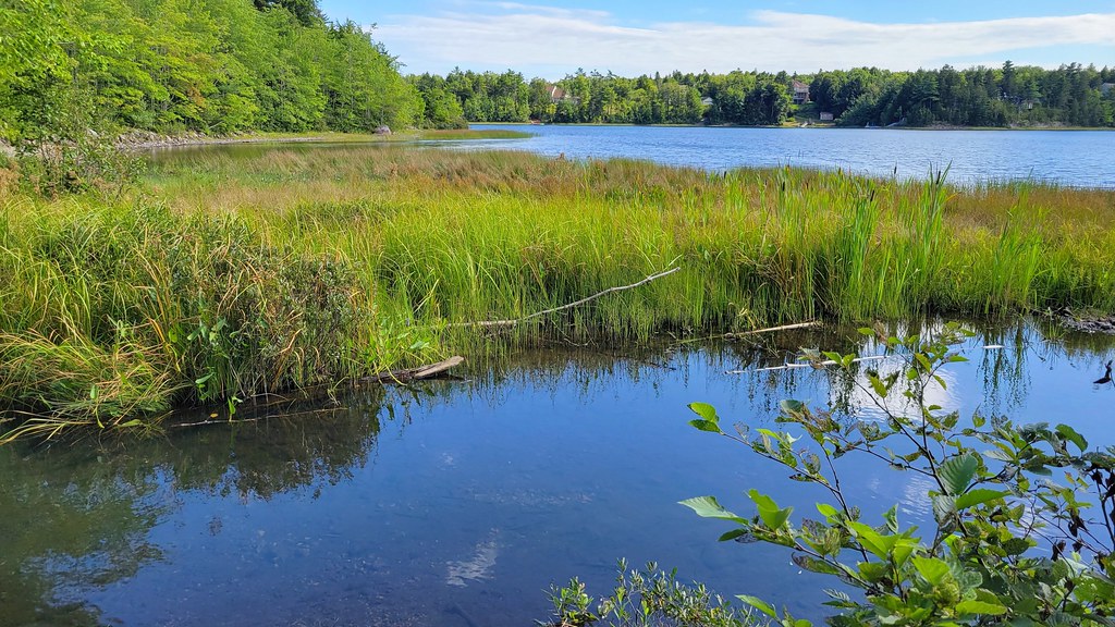
The final access point is via the dead end where Magenta & Margeson Drive meet. This trail leads to some scenic spots, including a river connecting McCabe Lake and Webber Lake. You’ll follow this wooded trail along Webber lake for just over 1km until it meets up with the other trails near the beach area.
Hiking Trails & Navigation
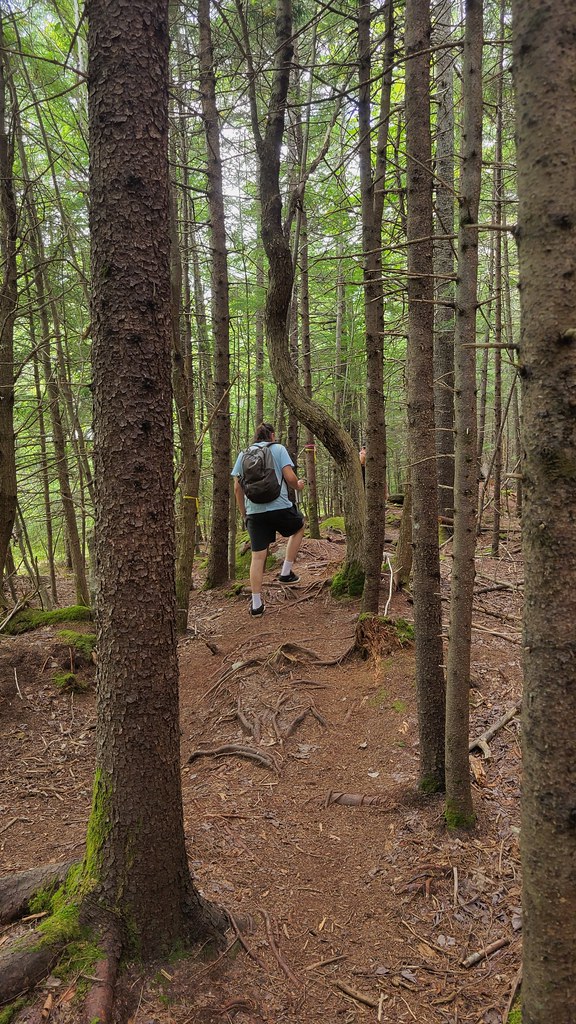
These trails are not maintained and are mostly unmarked. Since this is the case, there can be numerous side trails that can lead you off in the wrong direction or to a dead end. The web of trails makes it possible for you to do a circle around the falls without ever seeing them, as was the case for my visit. Be sure to pay attention to where you’re going if you intend to head for the falls right away. Otherwise, there are lots to enjoy just wandering the area as I unintentionally did. Use my map to stay on track, click here for a how-to.
Along the service road are a couple of trail entrances that are not the ones you want to head down, so don’t mistakenly take the wrong one unless you want to explore areas that I haven’t included on my map. The main trail itself is a loop with 2 separate entrances off of the service road.
In the center of this loop is the waterfall itself, and the river that feeds it. The waterfall trail is a linear 250m section that runs from a log footbridge near the access road at one end, to a midway point between the access road and Webber Lake at the other end. It’s well worth heading down to Webber Lake and exploring the trail that follows the lake toward the Margeson Drive dead-end.
Swimming & Fishing
 The waterfall area isn’t deep or big enough for swimming & during the hottest months, the water won’t usually be heavily flowing. For swimming, the beach area at Webber Lake is your best option. Be aware that blue-green algae is an increasing problem in Halifax lakes, largely due to road runoff and the political enabling of environmentally reckless building developments. There is a water quality monitoring program, staffed by volunteers, that monitors 76 lakes, including the adjacent McCabe Lake.
Speckled Trout are common in this lake. Though the beach at Webber Lake is easily accessible, the best spot for fishing is the stream that connects McCabe & Webber Lake. This stream has a few slow-moving branches and pools, it’s also a less-trafficked area. For licensing info click here, for info about regulations click here. For more outdoor adventures with fishing opportunities, check out my #fishing category.
My Webber Lake Falls Photos


Webber Lake Falls Trip Tips
If you plan on swimming at the lake or playing in the waterfall, water shoes are a good thing to have. They’re good for keeping leeches off your feet in lakes, as well as protecting your feet from broken glass in high-traffic areas like this. A packable towel is also a good investment for any swimming adventure.
In Spring and early Summer, you’ll want to pack some bug protection as they can be bad enough to ruin your enjoyment. Ticks are always present in Nova Scotia whenever temperatures are consistently above freezing. Read my Tick Avoidance Guide for more detailed info. In winter, traction spikes are good to bring to make your hike much safer and more enjoyable.
During peak times (warm weather weekends) this area can be quite popular. There isn’t a big area to park at the dead end of the service road, so if you arrive early, please leave room for others. Don’t box people in, and if you park on the side of the road, stick to the same side as everyone else & pull off as far to the side as you can.
These trails are not maintained, so please follow basic Leave No Trace outdoor ethics. There are no garbage cans, so pack out what you pack in, including used dog-poop bags.
Nature & Biodiversity
Click the links below to learn more about the local flora & fauna you’ll find near Webber Lake Falls. For a full list of local observations recorded on iNaturalist, click here.