Maps & Navigation
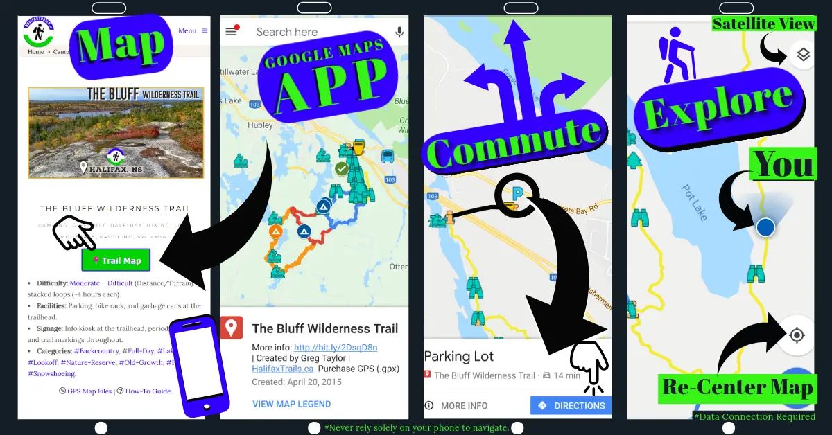
Each location has a link to a detailed map, intended for use on your phone’s Google Maps App (free for iPhone & Android). You can reveal or hide additional layers in the map like so. The Google Maps format is useful for turn-by-turn directions and as a real-time GPS reference on location (data connection required). Click the graphic below for a basic overview:
See this video tutorial for navigating with Google Maps. Some phones may be set to open Google Map links in a web browser rather than within the much preferable Google Maps App; Troubleshoot it for iPhone or Android. Disclaimer: Google Maps should be treated as an additional aid rather than your primary means of navigation. Its reliance on a cellphone network connection means it is not a dependable primary means of navigation (see the “GPS Maps & GPS Devices” heading below for more reliable electronic means). You should also set Google Maps to download areas to allow you to navigate offline (the custom trail map overlays still need a data connection).
Always carry a compass, printed map (a Topo map is preferable), extra battery, safety gear, & tell someone your plans. A satellite communicator is a good safety investment especially if you head out alone or into remote areas with no cellphone reception. Know how to use a compass. Do not overestimate your abilities, and ease gradually into being able to do more challenging adventures. Check out my “Bushcraft” curated playlist of videos to help further your outdoor knowledge.
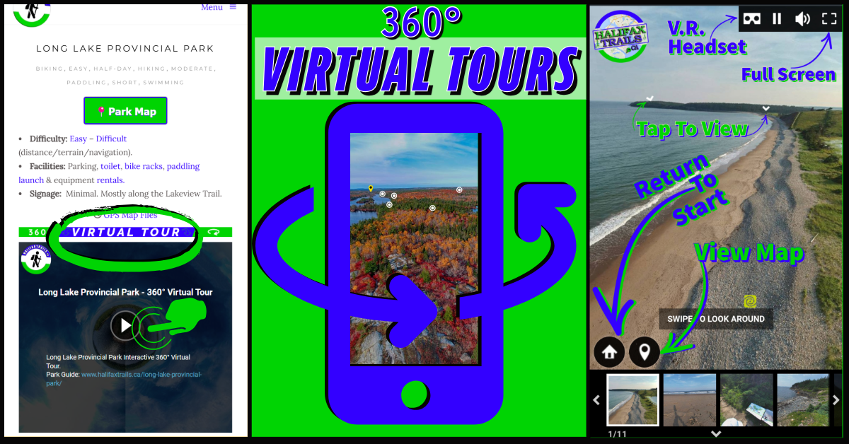
360° Virtual Views:
See how to view 360° Virtual Tours in the graphic below.
Immersive Viewing: Virtual Reality Headsets
For an extra-awesome view of these 360° photos (& 360° videos), use a readily available, inexpensive VR headset with your phone. Immerse yourself fully in each view and get an accurate feel for what the trails are like, or how it feels to be standing at that all-encompassing lookoff. You can view any of my 360° videos, in a similar fashion by watching them on YouTube. You don’t have to look far to find a decent, inexpensive VR headset (click here to shop on Amazon). A simple inexpensive one that uses your phone as the screen can be every bit as effective as the gaming models.
GPS Maps & GPS Devices
If you have a smartwatch or handheld GPS device, you can download GPS map files for use in your device. These downloads come with both .KML and .GPX file formats, the most common file types, which work in almost any GPS device. Each device will have a different process to load these files. Below are links to the most common devices.
•Garmin Basecamp: How to load, view and edit maps on your computer and transfer to your Garmin device.
•Apple Watch: Many GPS apps allow you to import KML files for offline GPS navigating, like this one.
•Google Earth: The Google Earth app and computer program is a powerful tool that allows you to easily edit any map. View these simple instructions on how to import GPS files into Google Earth. Google Earth & Google Maps mobile apps both require a cellular data connection to load custom maps. They do not currently allow custom maps for offline use as of Oct. 2019.
•Other GPS-enabled devices, including some smartphone apps, are capable of importing GPS maps for offline use (no cellular reception required). All of these methods should be tested in low-risk, familiar locations to gain confidence, and proficiency in their use. ALWAYS: 1) Tell someone where you are going & when you plan to be back. 2) Pack basic safety gear.
Outdoor Ethics
I offer these maps and guides for free because I believe everyone should have equal access to our most beautiful spaces. I don’t think they should be kept secret for a privileged, exclusive group. I have always believed the more people get into nature the better. While some scapegoat blame for litter and other damaging behaviour, I think seeing a diverse array of people on our trails is a good thing. I’ve seen young people with spotless ‘Leave No Trace’ wilderness campsites, I’ve seen ‘experienced’ trail users tossing poop bags into the woods, and vice versa.
I believe the more people who are exposed to the mentality-altering serenity of nature, the broader the public support for funding nature protection, green infrastructure, and a forward-looking, sustainable, eco-tourism-based economy. Creating a broad, diverse audience of outdoor adventurers comes less destruction. Hikers are many orders of magnitude less destructive than the chainsaws and bulldozers of our current unsustainable, polluting industries & irreversible developments that tend to pave over places that are only visited by an exclusive few.
I ask 3 things in return:
1) Follow Leave No Trace principles & Burn Safe.
2) Make it a habit to safely pick up & carry out any trash you see. Trash encourages more littering, but we can stop that cycle from starting.
3) Support local volunteer organizations, many of whom are mentioned in my guides. Find an organization working locally to protect nature and support them any way you can. Whether it be financial support or as simple as liking one of their social media posts, everything helps. Be an engaged citizen and make yourself familiar with our environmental issues and the people addressing them. Have your voice heard: cast informed votes & realize the effectiveness of contacting your elected representatives with comments and concerns.
My blog is the result of countless hours of solo work. At this project’s core is wanting to keep it free & unrestricted for all. Your support will help me to continue adding, updating, improving & ensuring it stays a free resource for everyone regardless of their ability to pay.
