Lake William Trail Info:
- Difficulty: Easy – Moderate (Hills). View elevation profile.
- Facilities: Parking.
- Signage: Trail map at the trailhead. Interpretive panels on local natural features.
- Features: 5km loose gravel trail. Scenic pedestrian bridge. Hilly terrain, winding through wetlands & alongside Lake William. Still under construction with improvements to come.
- Biodiversity: View William Lake Trail species observations on iNaturalist.
- Tags: #Bridge, #Family-Friendly, #Fishing, #Lake, #Mountain-Biking, #Picnic, #River, #Snowshoeing, #Wetlands.
Lake William Trail Partnership
The Lake William Wetlands Trail is a public/private partnership that includes the Province of Nova Scotia, Halifax Regional Municipality, The Trans-Canada Trail & support of the land owner, Sovereign Resources Inc. The Shubenacadie Watershed Environmental Protection Society (SWEPS) has agreed to maintain the trail. All parties ask that you please stay on the trail & respect the watershed, as is the intention of its creation.
A Work In Progress
This 5km active transportation trail is, for now, one way, up and back. Due to a breakdown of land negotiation, a key piece of privately owned land is keeping the trail from joining the Shubie Greenway Corridor Trail. As the trail was only recently opened, its surfacing is still in the early stages. As of now (summer 2023) the trail surface is rough gravel, not well suited for strollers, road bikes, or people with mobility issues. The surface will eventually be smoother, compacted crusher dust typical of most non-paved rails-to-trails routes in the region. Since improvements are ongoing, be sure to pay attention to any signage warning of current trail work.
Parking & Access
The parking lot at the trailhead is currently quite narrow, with very limited space to turn your car around. You’ll want to pack in, or have your car face the main road if you want to have an easy exit. As the lot fills up, your opportunity to get turned around will be extremely limited. That being said, make sure you leave room for others to maneuver by keeping as close to the edge as you can and leaving room between the cars in front & behind you. Make sure you don’t park directly in front of the gate, as it is used for trail maintenance. You can be towed if you block this gate, so make sure to leave a couple of car lengths in front of it.
Powder Mill Park
 Another parking option is at nearby Powder Mill Park. This roadside picnic park has room for 10-15 cars and is located just a few meters down the road. Parking here will require you to cross busy Rocky Lake Drive with no crosswalk, so if you have kids in tow you’ll have to use plenty of caution.
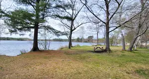
Powder Mill Park, located on Powder Mill Lake, has numerous picnic tables beside the lake, and is a good spot to access the lake for a swim or paddle. Take care when you park here to leave room for others & also do not box them in. Careless parking can waste precious space. This park can fill up quickly on a nice day so don’t assume it will be empty for long.
Lake William Wetlands Trail
Starting at the trailhead where a bench sits next to an info kiosk with a map & important information about the trail. Similar signage is posted throughout distinct areas of the trail. The first kilometer of the trail is relatively flat, but it begins some up & down dips in its second kilometer. The ups & down rollercoaster feel starting on the second kilometer makes for fun mountain biking and plenty of exercise. It’s easy to build up too much speed on the downslopes, so make sure you can see well ahead of you before you pick up speed. From a walking perspective, the first kilometer of the trail is a good warm-up before you start working your legs with the repeated up-and-down slopes that start on the second kilometer.
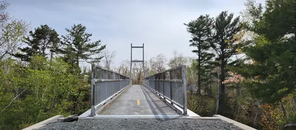
The first major landmark on the trail is its most iconic aspect; a large suspension bridge. The Lake William Trail Bridge was a project spearheaded by the Shubenacadie Watershed Environmental Protection Society & local residents. On an adjacent plaque, you can read the full list of teamwork that made this well-built structure possible. Be sure to take a moment to stand in the middle of the bridge to admire one of the best views on the trail. After crossing the bridge, bikers are asked to dismount as this is one of the steepest hills on the trail, with poor visibility at the bottom.  After a few more ups and downs and another kilometer of trail, you’ll come to a stream and the next steepest hill of the trail. Fortunately, this dauntingly steep hill is simply an option. A side trail skirts the hill with a curving, less strenuous climb while only adding a few more meters in distance compared to taking the hill head-on. The next 400m of trail is more wooded with cutouts in place for what looks like spots for future benches.
The Lake William Wetlands Trail will inform you about your surroundings at key points along the final kilometer of the trail. 5 different locations are marked by informative signage about the nature of your current surroundings.
What Are Wetlands?
The first sign is amongst a geologically compelling area marked by an exceptionally monumental boulder. This part of the trail is a leadup to the biodiverse final kilometer. A posted sign titled “What Are Wetlands” explains just that. You’ll learn the physical characteristics, benefits & their vital role in healthy ecosystems. Information from this part of the sign is sourced from the Nature Conservancy of Canada.
Mi’kmaki: The Lands That We Share
The other half of the sign discusses the connection between humans and healthy ecosystems from the perspective of First Nations people; the indigenous Mi’Kmaq who spent many millennia living in balance with these lands. The sign discusses how wisdom handed down through thousands of years can serve as a timeless guidestone. You’ll learn Mi’kmaq names for specific types of land they held in particular reverence. Information from this section is sourced from IKANAWTIKET (ee-gone-aawh-dee-get), an initiative of the Maritime Aboriginal Peoples Council.
Graminoid Fen
After the first Wetlands Trail info sign, the trail begins a downslope toward an iconic wetlands view of a marshy Lake William inlet. This part of the trail has another sign titled “Graminoid Fen”, which explains the new-to-me geographic term. It’s always great to learn some new knowledge with an example right before your eyes, and this spot is perfect for that. You’ll learn precisely what a Graminoid Fen is, how it differs from a bog, and what mosses & trees make up this microhabitat. Information about one of the lake’s most melodic species of inhabitant, the Common Loon, is also covered in depth.
Shrub Bog
After a steady uphill, the next sign is near another eye-catching boulder that begs to be climbed. This elevated part of the trail has a picturesque view of a wetland clearing known as a shrub bog. The sign explains what makes up a bog including its most common trees and plants. Spotlighted is a species of interest known as Labrador Tea. This plant’s common name comes from its high vitamin C content which was historically used as a tonic to treat scurvy.
Treed Bog
After plateauing atop a high point with a rolling hill view, the trail is more forested. This segment of the trail shows how wetlands can exist not just alongside or within water courses, but also in woodlands. The “Treed Bog” sign explains the specifics about what features are unique to this common type of Nova Scotia wetland. As you’ll read, trees like Red Maple, Black Spruce, Tamarack and Balsam Fir are especially well adapted to thrive in these conditions.
The semi-aquatic Wood Turtle is spotlighted on this panel, as this species enjoys wet forested areas more than any other. This specific microhabitat is where a Wood Turtle lives its best life. From berries to slugs, these reptiles have an all-you-can-eat buffet when in their bog element. This turtle is listed as “threatened” under the Nova Scotia Endangered Species Act as its preferred habitat is increasingly inflicted with destructive human activities.
Shrub Fen
 Marking the end of the trail is a scenic river feeding into Lake William. A small log bridge spans the narrowest part of the river, making for a good viewing platform. The trail is closed at this point for now, as planning continues in hopes of connecting the trail to the Shubie Canal Greenway Corridor.
The end of the gravel trail is marked by a couple of signs, one of which warns of Poison Ivy in this area. The other sign is the final of the wetlands information panels, this one titled “Shrub Fen”. It explains how water depth & chemistry make this area ideal for shrub growth.
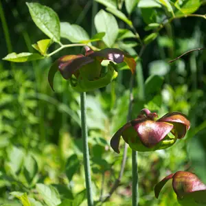
The panel highlights the Purple Pitcher Plant as a species of interest in this area. This stock of this carnivorous plant is a perfectly designed, pitcher-shaped water reservoir with downward-facing hairs that trap anything looking for a drink. A literal thirst trap. The resultant insect soup is what this fascinating plant gets its nourishment from. Beyond insects, these plants even trap small rodents & reptiles as ingredients for a hearty stew.
Lake William Trail Tips
As stated previously, this trail is still in the early stages of being finished and its substrate is an example of that. Currently, (2023) it is still a loose gravel base which requires proper hiking footwear and an off-road capable bike. Strollers, running shoes and road bikes may be suitable in the future when the trail is finished with smooth, compacted crusherdust.
Be prepared for bugs as various spots in the wetlands areas can be especially bad for bugs in Spring and early summer. As this trail is still an up-and-back trail, you’ll want to keep track of your distance if you’re not committed to the full 10km return trip which is a substantial trek if you’re on foot. If you’re walking, be sure to keep your head up to look out for bikers who may be going faster than they should. Keep an eye on children and keep dogs on leash for the same reason.
If you’re biking the trail, expect lots of hill climbs. Though it’s only 10km, there are plenty of thigh-burning ups and downs to test your cardio. It’s best to bike this trail during less busy times. Its narrow, blind corners can cause dangerous situations with walkers, and there can be lots of them on nice days later in the day and on weekends.
This trail is the result of a lot of blood, sweat & tears by local volunteers. Don’t insult their selfless work by dirtying this beautiful trail with garbage. As always, use Leave No Trace outdoor ethics & pack out what you pack in. There are currently no garbage cans on the trail, and there weren’t even any at Powder Mill Park when I was there in Spring. Make sure your dog walking gear includes a way to pack out dog waste. It’s wise to keep something like an empty peanut butter container in your car for just such situations.
SHOP.HALIFAXTRAILS.CA: Books | Gear | Sale
Aquatabs 49mg Water Purification Tablets, 100/pack (Canadian Format), Easy-to-Use Water Treatment for Hiking, Backpacking, Ca...
$20.87 (as of 19:49 GMT -03:00 - More infoProduct prices and availability are accurate as of the date/time indicated and are subject to change. Any price and availability information displayed on [relevant Amazon Site(s), as applicable] at the time of purchase will apply to the purchase of this product.)Join The “Halifax Trail Talk” Facebook Group.


