Blue Mountain-Birch Cove Lakes: Kearney Lake Trails
- Difficulty: Difficult (Terrain/Navigation).
- Facilities: None.
- Signage: Minimal markings & signage. Periodically posted trail maps.
- Features: Part of the extensive Blue Mountain-Birch Cove Lakes Wilderness Area. Rugged, unmarked #Backcountry trail system for experienced hikers. Trails encompass Charlies, Fox, Ash & Hobsons Lake.
- Biodiversity: A vital near-urban sanctuary featuring old-growth Acadian forests, rugged granite barrens, and a surprisingly diverse array of wildlife ranging from elusive bobcats to iconic common loons (view the Nature section below).
- Trail Conditions: View and sign the Logbook below for updates from fellow explorers.
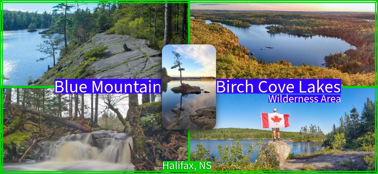
Blue Mountain Birch Cove Lakes Wilderness Area
Minutes from downtown, one of Halifax’s most popular summertime destinations, Kearney Lake, has always been a popular swimming and paddling spot. World-class Maskwa Aquatic Club‘s rowers can be seen training on the lake daily as beach-goers enjoy a day at its supervised beach and children play on the nearby playground. Tucked behind this popular recreational lake is an extensive wilderness with stunning views and access to 4 different 100% wild lakes, numerous ponds, streams, waterfalls & hidden gems galore. Only recently has this area become a popular outdoor recreation destination in itself.
Parking & Hiking Trail Access
The best parking is a large gravel area adjacent to Maskwa Aquatic Club. This land is leased by Maskwa and it’s due to their kindness that you can park here. Their land is leased purely for the purpose of running a paddling club and they do not maintain the trailhead or have anything to do with people hiking here. Do Maskwa a favour in return by packing out what you pack in. Do not use Maskwa’s designated parking or block access to their property in any way. Keep in mind that the drive into Maskwa passes by a municipal beach and playground with children running around. Saskatoon drive is a quiet neighbourhood with children, so keep speeds very low on your way in and out from Kearney Lake Road.
A second way to access this area is via the end of Colins Road. This quiet cul-de-sac has limited parking and can often be overflowing with cars during peak times. For a period of time, the NS government forced Maskwa to disallow access, making Colins Rd. even busier. Make sure not to block driveways, keep noise levels to a minimum, and pack out what you pack in as there is no garbage collection. Colins Rd. is typically used for easy access to Hobsons Lake, but both access points are equally fine starting points to explore this area should one be overly full of cars.
Until this wilderness park comes to fruition, access will continue to be limited. The jumble of trails can’t be improved until the park is created from its current patchwork of land ownership, so be sure to keep the pressure on our local governments to fulfil their decades-long promise to create it. The best way to do so is to become a (free) member of the Friends Of Blue Mountain-Birch Cove Lakes Wilderness Society.
My BMBCL Photos


For Experienced Hikers
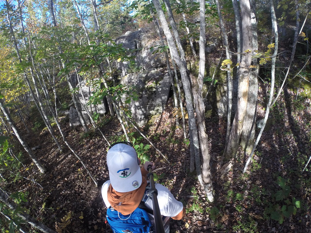
Ideal for experienced hikers and those who know their limits. Wooded navigating experience, a dedicated GPS device and a compass are must-haves for newcomers to these largely unmarked trails.
Off-road biking isn’t great yet, as the trails are full of roots and other obstacles. Camping is allowed on public land unless otherwise stated, but it’s discouraged here. There are no designated Leave-No-Trace campsites or ideal spots as yet, but huge potential awaits if/when this area officially becomes a long-promised wilderness park.
A Tangled Web Of Hiking Trails
 The Kearney Lake trail is a wide, linear, worn natural path that follows along the shore of Kearney Lake. It takes about 45 minutes to go to the end and back (about 2km total), with a view of venerated “popcorn island” at one of its most scenic points. This trail is a good introduction to the area as it stays out of the remote areas. It also gives you a taste of what the backwoods trail system is like, without straying far from Kearney Lake.
There is a more extensive 40-acre trail system that loops through the backwoods, and around smaller, remote lakes. Hobson’s Lake, Charlies Lake, Ash Lake, and Fox Lake can all be accessed by the backcountry trail system. These trails take substantially longer than the trail that follows along Kearney Lake and requires planning and preparation. Many side trails and crisscrossing splits can lead you off into unintended directions.
You can spend as little as an hour or as long as an entire day in this extensive wilderness. From my experience, it’s always good to allow plenty of time for wrong turns and substantial stopping time to take in the all-encompassing scenery. The wooded trails are dotted with huge old-growth trees, rock formations, rare plants and wildlife that you do not typically see within city limits. Each lake has its own special look-offs and stopping points where you can easily spend hours.
Suggested Loops
With the tangled web of unmarked trails, it can be very easy to get overwhelmed. Rather than having to stop every few feet to figure out where you want to go, I’ll offer a few suggestions according to difficulty. Keep in mind that “easy” is relative, and that it’s entirely possible to get off track even on an easy loop. Click here to learn how to use my resources to assist your navigation.
Kearney Lake – Maskwa Club Trail (Short)
The easiest option amongst these trails is to stroll the shore of Kearney Lake (marked in purple on my map). This trail is known as the Maskwa Club Trail as it is adjacent to the Maskwa Aquatic Club. 1km in length (2km up and back), it’s great for a quick stroll using the lake as an easy frame of reference to avoid going off track. The trail runs from the Maskwa parking area, to the Colins Rd. parking area, but I’d recommend Maskwa, as Colins Rd. can fill up quickly during peak times.
You can up the difficulty by turning this into a loop. From Colins Rd. taking the 600m “Paddler’s Ridge” trail that connects to Charlie’s Lake, and then from Charlies Lake to the Maskwa parking area (another 800m) for a total of roughly 2.5km. Beware that this loop is an introduction to the difficulties of navigating these trails, as there are many intersecting paths. Allow 1 hour for a lakeside stroll, 2 hours for the loop.
Charlies Lake Loop (Moderate)
At just over 4km in length (2-3 hours), the loop around Charlies Lake is one of the most iconic hikes of the Blue Mountain-Birch Cove Lakes wilderness area. This loop can be accessed from either the Maskwa (marked in yellow on my map) or Colins Rd. trailheads, with slightly more difficult terrain leading from Maskwa, where you’ll have to do some moderate climbs that can be slippery in wintery or wet conditions. Either choice is roughly the same length.
This trail follows the shoreline of the long, narrow lake (850m long, and mostly under 100m wide). The Northern shoreline is especially scenic, with one of my favourite spots in Halifax. This amphitheatre-like atmosphere is a good place to stop and enjoy your surroundings (the secret is out, so you might not be alone on a nice day). If you want to keep your hike easy, you can just stroll this side of the lake and head back the way you came.
For a more extensive hike, doing a full loop of the lake involves a crossing that can be difficult depending on the water level. Other than a crumbling cabin, landmarks are fewer on the Southern side, as the trail ventures farther away from the lake and into dense forest. For those reasons, I’d recommend doing the loop in a clockwise direction so you can get a feel for things before venturing into the more difficult parts.
4 Lake Loop – Hobsons, Ash, Fox & Charlies Lake (Long)
Once you’re accustomed to the topography and navigational challenges of this area, bigger loops are the perfect way to experience all of the best spots this urban wilderness gem has to offer. Be sure to go into these hikes fully prepared, and don’t play it close to sunset, as it’s likely you’ll make a wrong turn or two and spend more time than you anticipated taking in the multiple lake views.
The shortest option is just over 5km long (3+ hours), a loop that doesn’t involve lots of climbs or drastic elevation changes, but what it lacks in that, it makes up for in ruggedness. This interior loop skirts by the shores of Hobsons, Ash, and Fox Lake (route marked in red on my map). The most efficient route is to start from Colins Rd. and do a counterclockwise loop starting with Hobsons Lake and finishing with Fox Lake. You can add a fourth lake (and significantly more time & difficulty) by taking the rugged but scenic, 940m Mike’s Trail (in orange on my map) to a midway point on the Charlies Lake loop (4km).
Adding a 3.5km (1 hour) loop around Ash Lake (marked in blue) and/or a 4km (2 hour) loop around Charlies Lake (marked in yellow) to the previously mentioned interior 5km (3 hour) route (marked in red) will give you the full tour of this area (roughly 13km & 6-7 hours), but adds significantantly more navigational challenges, so only attempt this one with plenty of preparation, prior experience, and start as early in the day as possible.
Protection Efforts
2026 Update: Blue Mountain-Birch Cove Lakes Wilderness Area under threat of development (AGAIN). Premier Tim Houston has made a unilateral decision to include this area in his “special planning areas” for “fast-tracked” housing, aka unnecessary, unaffordable urban-sprawl for politically-connected developers. Despite successful efforts in the past to keep this area free from development, thanks to the overwhelming outpouring of support from the people of Halifax, this unprecedented, anti-democratic, anti-science, authoritarian “fast tracking” threatens to destroy key parts of this wilderness area once and for all. Learn more here, and contact your political representatives to stand up for basic democratic norms & nature!
The Kearney Lake trail system used to be largely inaccessible, known to only a small number of hikers and mountain bikers. The trails have evolved over the years with no one to oversee their maintenance or development. The newly formed Friends of Blue Mountain-Birch Cove Lakes have stepped in to spearhead an effort to protect this area once and for all. If protected, much-needed re-vamping, marking and maintenance will be allowed to occur, turning the trails into a comprehensive system with variable offerings for people of all abilities. The Nova Scotia Nature Trust recently stepped up to protect a key, core area of this proposed wilderness park, but more will be needed to fulfill this decades-long promise by various governments.
Whether it’s a swim in the lifeguard-monitored beach, a paddle on Kearney Lake, or a hiking adventure through the unspoiled backwoods, this area has a lot to offer. Plans to make it more orderly, safe and accessible are on the back burner while government entities work to purchase and protect the required land. Boasting what would be North America’s largest urban wilderness park with aspects akin to Kejimkujik National Park would be great for Halifax’s resume, and there are people committed to making it happen. To contribute to the protection of this area, and the creation of the Blue Mountain-Birch Cove Lakes Wilderness Park, support the work of volunteers with the Friends of Blue Mountain-Birch Cove Lakes and become a (free) member.
Nature & Wildlife
Despite its proximity to urban Halifax, the Blue Mountain-Birch Cove Lakes Wilderness Area is a thriving ecosystem that offers a genuine backcountry experience. The varied ecosystems, from sun-drenched granite barrens to deep, shaded ravines, support a stunning array of Acadian forest flora. As you weave through mature stands of Eastern Hemlock, Red Spruce, and Yellow Birch, keep an eye on the forest floor for vibrant Pink Lady’s Slippers, translucent ghost pipes, and dense, spongy carpets of sphagnum moss lining the wetland bogs. The area’s ancient deadwood and erratic boulders are also a haven for resilient lichens and striking fungi, like the Northern Red Belt, which thrive in the damp microclimates near the lakes.
This sprawling, rugged habitat is also a vibrant sanctuary for over 150 bird species and a surprisingly diverse mammalian population. Your hike will be soundtracked by birds, like the drumming of Pileated Woodpeckers, the hoots of Barred Owls, or the haunting, echoing calls of Common Loons drifting across Charlies or Fox Lake. For the sharp-eyed explorer, the trail frequently yields sightings of white-tailed deer, snowshoe hares, and the telltale chewed bark of beavers actively reshaping the local waterways. If you’re incredibly lucky (and quiet), you might even spot the tracks of the elusive bobcats, coyotes or bears that stealthily share this urban wilderness. View and record Blue Mountain-Birch Cove Lakes Wilderness Area observations on iNaturalist.
Trip Tips
The trails can be icy, muddy, bone-dry and everything in between according to the season and the recent weather. Expect to hike up an incline at some point on almost every trail, and have your balance tested when trying to avoid muddy patches or making difficult crossings. You’ll want to wear sturdy waterproof footwear, pack a first aid kit and basic survival gear for all wilderness trips. Bugs are worst in Spring & early Summer, and ticks exist throughout Nova Scotia for much of the year, so bring your favourite form of bug defence.
Looking for a fun, outdoor adventure to complete with family and friends at Kearney Lake? Try “The Stolen Seed Caper” to become a Kearney Lake Nature Patrol and solve the mystery of the stolen seeds. The step-by-step instructions for this 1.2 km (return) trail adventure and a route map can be downloaded at earthadventures.ca. The approximate time to complete the adventure is 1 hour and 15 minutes.