

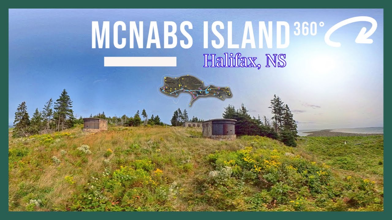
McNabs Island Provincial Park Info:
GPS Map Files | How -To Guide.
- Difficulty: Easy – Difficult (Distance). Elevation profile.
- Facilities: Covered picnic area, toilets, and benches throughout.
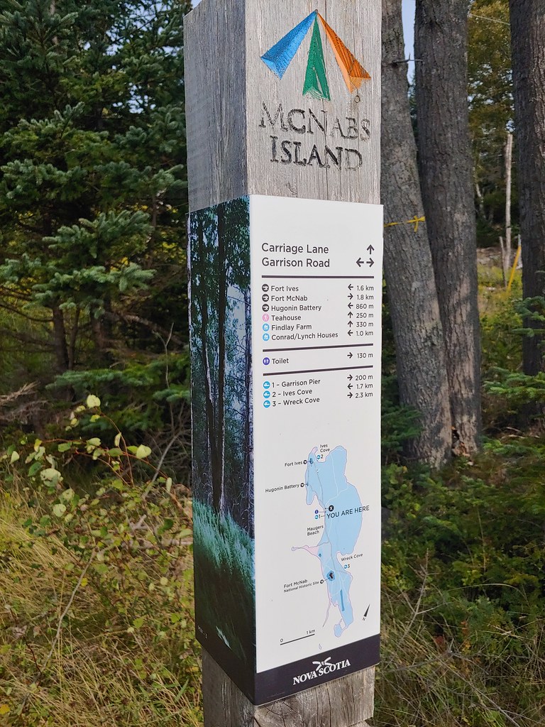
- Signage: Info kiosk, signposts with maps and distances marked at every key juncture.
- Features: 400 hectares of wilderness with over 20km of hiking trails. Historic site with forts & stories from many eras. Spectacular nature gem with sand beaches, rugged coastlines, mixed forest, old farmland & wetlands.
- Habitat: Eastern Coyote | Drumlin | Osprey | More…
- Tags: #Beach, #Bird-Watching, #Camping, #Coastal, #Family-Friendly, #Historic-Site, #Lighthouse, #Lookoff, #Old-Growth, #Park, #Picnic, #Wetlands.

McNabs Island Provincial Park
Getting There: Shuttle, Ferry, or Paddle.
Finding a way to access the island has long been a barrier preventing many Haligonians from visiting the island (including myself). Thankfully in recent years, it has become much easier to coordinate a trip tailored to your requirements. From a large sea ferry to small zodiac shuttles, there are many different options. The main consideration to start with is where you’d like to be picked up.
When I visited the island, I opted to get picked up from one of my favourite local parks, Sir Sandford Fleming Park, away from the hustle and bustle of downtown, nearer my neighbourhood, and with the bonus of cruising Halifax’s beautiful Northwest Arm. Captain Dave with his Northwest Arm Boat Tours & McNabs Island Shuttle was able to accommodate our requested departure and pickup times with friendly, insightful, on-time service.
A&M Sea Charters, Taylor Made Tours and McNabs Island Ferry out of Eastern Passage, near MacCormack’s Beach Provincial Park & beautiful Fisherman’s Cove are other good options as the fastest, most direct route to the island. For those looking to paddle to the island, Eastern Passage is the only recommended launch point. A 2km sea-worthy paddle from Eastern Passage, past Lawlor Island to Wreck Cove on McNabs Island, the water on this side of the island is considerably calmer. From downtown Halifax, you have the options of Murphy’s Cable Wharf (good for large groups) and Halifax Water Taxi which also does pickups at King’s Wharf in Dartmouth.
Route Planning
With over 20km of trails, there’s no shortage of route options. The large, 400-hectare island has a main trail stretching almost 5km from end to end. Garrison Road is the main spine trail that extends 3km from end-to-end with direct connections to almost every trail on the island. When planning your day, my basic recommendation is to allow a half-day (~4 hours) to explore each end of the island. You can easily spend an entire day in any particular section, or quickly tour the main sights on each end of the island in one 8-hour day involving plenty of hiking. If you want to cover the entire island in-depth, however, I would consider breaking it up into separate day trips.
#Biking on the island is allowed, however, it’s restricted to a couple of the main trails. The only practical reason to bring your bike would be to bike down Garrison Road to reach either end of the island much faster than walking. Garrison Road trail does not have ideal surfaces for biking, so it’s suitable only for off-road mountain bikes.


Guided Tours
The Friends of McNabs Island (a volunteer, non-profit organization), are responsible for most improvements to the island in recent years. The fact that the island is very easy to navigate is thanks to their work. In addition to all the behind-the-scenes work they do, they also run guided tours of the island as a fundraiser. On top of supporting an organization that deserves it, the tours are worth every penny as they are done by the people who know the island best. From their Spring cleanup events, Fall foliage tours and history walks they are regularly offering guided tours. Follow them on Twitter, Instagram or Facebook to stay up to date.
McNabs Island Hiking Trails
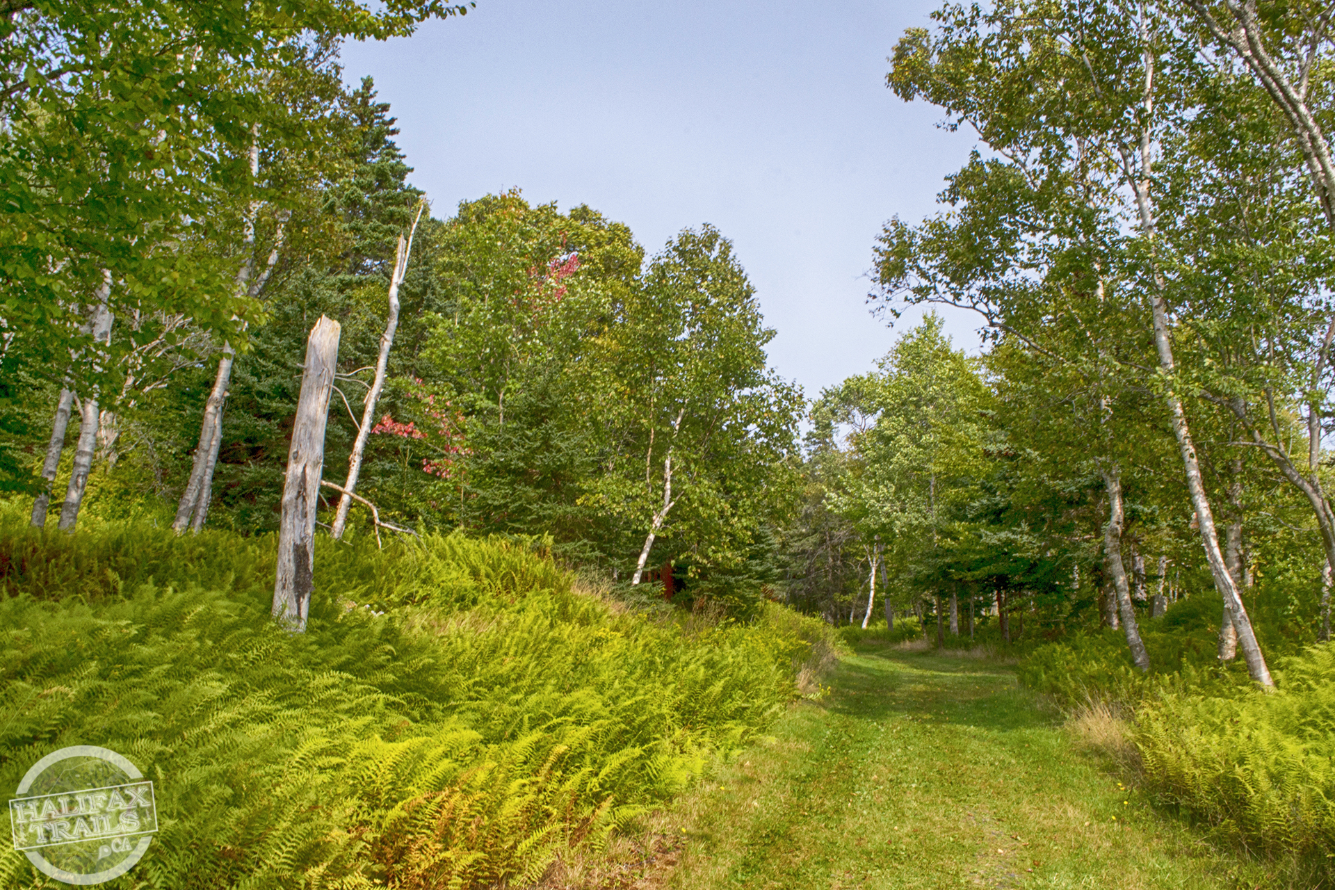
The trails are well-marked, mapped & maintained. Elegant signposts are placed at every key juncture and include all vital information for each location, including a map, directions & distances. All of the main trails are wide, readily identifiable, and well-traveled. Lesser-used paths can be overgrown and much more rugged. My advice would be to not venture down paths you don’t feel comfortable with, depending on your hiking experience level. All of the island’s main points of interest (with the exception of the lighthouse) are reachable without having to venture down paths that I’d recommend only for experienced hikers. While not impossible to get lost, if you stick to the main trails you should be fine.
The trails are not exceptionally hilly, but there are short distances that require extra exertion due to their gradual incline. Most of the trails are like what you’d see from an ATV trail, but much flatter and maintained to avoid any significantly challenging terrain. Some side paths go through dense vegetation that can be overgrown at times but do offer colorful natural views.
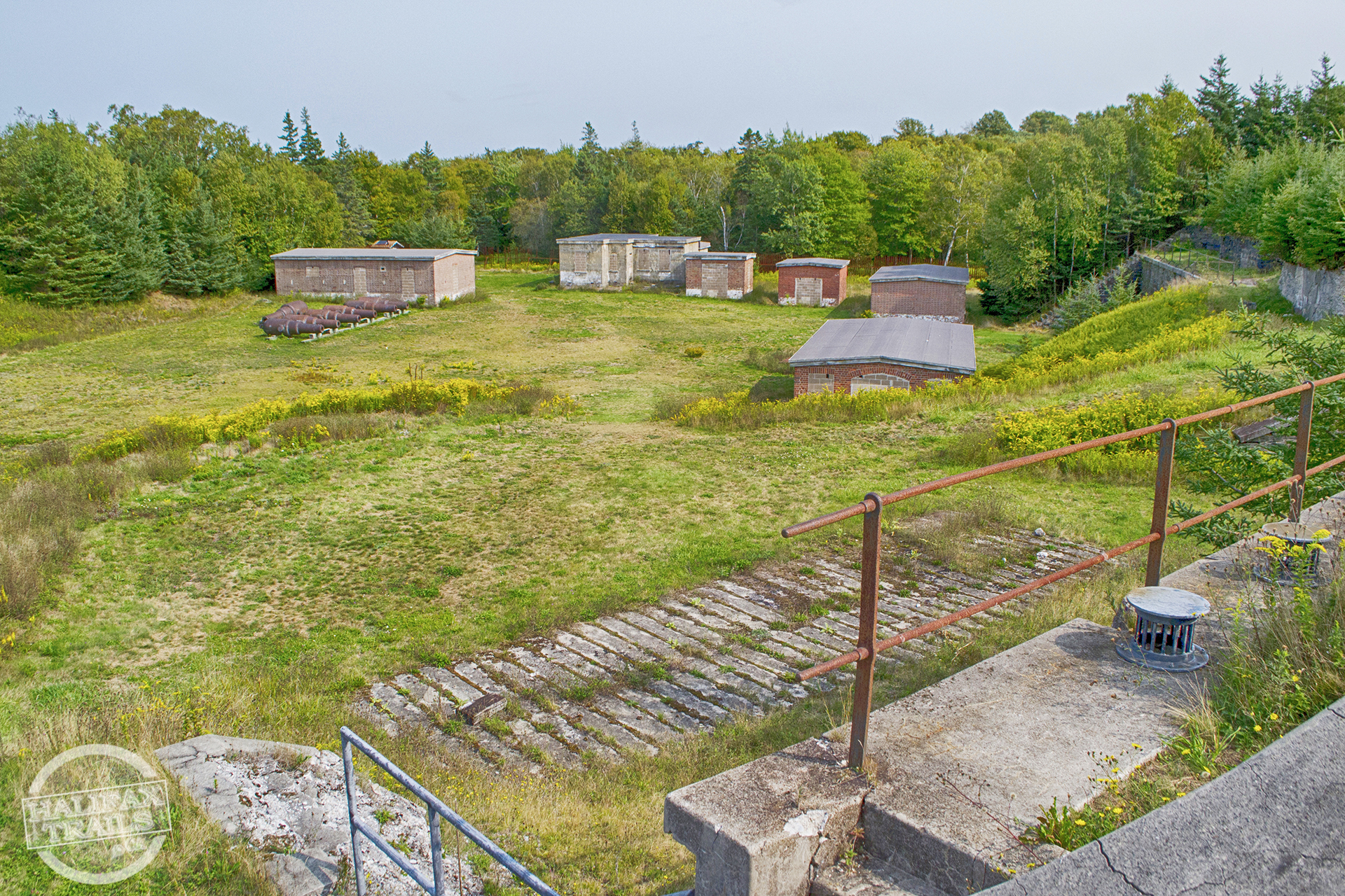
Part of what makes McNabs such a great destination is that there is no particular standard route. You can explore the military history, natural history, and cultural history of the island no matter what route you choose. The Garrison Road trail runs directly from Wreck Cove and Fort McNab near the center of the island to Fort Ives on the North end of the island. The South end of the island has more rugged trails and off-the-beaten-path destinations that I’d only recommend for seasoned hikers.
Points Of Interest
McNabs Island – South End
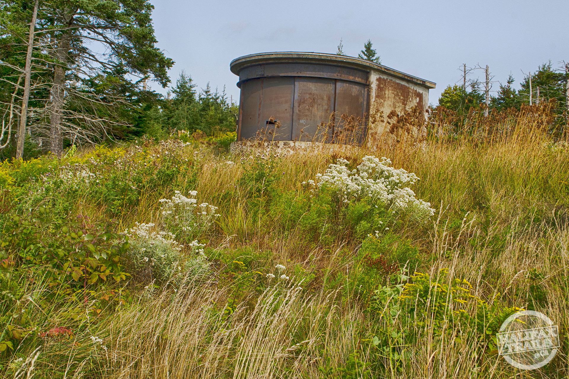 On my last visit to the island, I tried to cover as much ground as I could in 6 hours, stopping to take the many photos and videos you see in my guide. I was able to start from Garrison Pier where I then headed South to the searchlight emplacement, with stops to see the Lighthouse Trail, Wreck Cove, Fort McNab along the way.
The crumbling lookout building in Fort McNab is still accessible and allows you to share a centuries-old view. Fort McNab is a striking blend of natural beauty and hints of the past. The nearby McNabs cemetery contains huge, centuries-old headstones so beautifully carved that you can’t help but feel a human connection to the stories lived on this island. The headstones read as island family histories with the tragically young and splendidly old alike. I spent the morning exclusively in these Southern areas of the island, and could easily have spent longer.
McNabs Island – North End
Doubling back toward the Information Kiosk adjacent to Garrison Pier, I was picking up the pace to be able to explore the North end of the island before my scheduled departure time. I stopped for a quick lunch at the info kiosk and took stock of how much water I had left in my hydration bladder. In the September heat, I burned through more than half of the 2L I was carrying. Fort McNab and Wreck Cove are both good #picnic spots, the latter with a picnic table on the sandy beach near Drakes Gut.
After lunch at the info kiosk, I walked 200m to check out the nearby building known as the teahouse, where the Friends of McNabs Island Society are doing restoration work in hopes of turning it into an outdoor education centre (support them to help with the project). The society has already put together extensive educational resources for parents & teachers online, but the teahouse would definitely serve as an ideal educational centre for visitors.
I continued on toward Fort Ives on the North end of the island with a stop at a scenic bench in Finlay Cove. At the end of Garrison Road, where it continues on as Forsyth Street, is the Hugonin Battery. From here is a small trail that leads to scenic Hugonin Point and the burial site of cholera victims from the SS England in 1866. Unfortunately, I was strapped for time so I did not make it to Hugonin Point and didn’t fully explore the Hugonin Battery.
Forsyth Street was especially scenic, with a couple of very peaceful places to sit along the way. Nearing Fort Ives, you’ll pass by the Jack Lynch House (of local “Bill Lynch Fair” lore). Fort Ives along with Fort McNab are the two main attractions as far as the island’s military history goes. Fort Ives has great views of Halifax Harbour, while Fort McNab has wider ocean views. Just over 100m beyond Fort Ives is the second of two wharves on the island, known as the DNR wharf. Another trail branches off to Ives Point 300m in the other direction.
 Ives Point is witness to multiple shipwrecks dating back to the 1800s when it served as the main entrance to McNabs Island. It has great views of Halifax Harbour, and was once an anchor point for a WWI anti-submarine net used to protect the harbour.
Unfortunately, I didn’t have time to explore the other trails on the North end of the island such as the Old Military Road and Fraser Farm Trail, but both offer hours more of exploring. A 1km trail connects to Timmins Cove on the eastern side of the island, where bomber plane wrecks from the 1940’s & 50’s sit across from CFB Shearwater. The Timmins Cove trail also passes by old farmland and even the former site of a soda pop bottling factory dating back to the early 1900s. These areas of the island are the most remote, and some land in Ives Cove, alongside the Indian Point trail, is private property.
Mauger’s Beach Lighthouse
The Mauger’s Beach Lighthouse is perhaps the most iconic structure on the island. Unfortunately, it’s also not safely reachable and is best viewed from afar. Gone are the days of my childhood when visiting the lighthouse was easy thanks to a long boardwalk that is now largely washed away. The short (350m) Lighthouse Trail does not in fact lead directly to the lighthouse, as it gets cut off by fast-flowing water that fills and drains the scenic McNabs Pond Estuary with the tides. I would not advise crossing it even if conditions seem fine, as that can change by the time you head back. This salt marsh estuary is scenic on its own, and a great place for #birdwatching.
A much more indirect route is along the (800m) Colin Stewart Trail which ends at the Strawberry Battery, and then would require traversing a rocky shoreline of Hangman’s Beach. This Beach is the most notorious location of the island and is the subject of a historical fiction titled “Hangman’s Beach” by legendary Halifax author Thomas Raddall. Here the British Navy used to hang, tar, and display deserters as a macabre warning. This beach is not an easy place to walk, and the crumbling connection to the lighthouse is nearly entirely washed away. I would advise against trying to reach the lighthouse this way also, as it is not worth the effort and risks involved. On top of the hazards of walking this area, lay other (rare) hazards in the water. Recent efforts to tag and track great white sharks have resulted in at least one being pinged directly next to the lighthouse (personally, I think that’s pretty awesome).
McNabs Island History
The island is chock-full of history from every era of Halifax’s past. From cultural, military and natural history, the island has hints of it from end to end. The natural beauty of the island is enough to demand a visit, but the stories of its past add extra interest. You can stumble upon remnants of its past no matter where you are. Old apple trees, curious clearings, shipwrecks, and mysterious structures are there for you to ponder along your journey. I won’t bother to get into the vast amount of history contained on this island as I couldn’t do it justice. When you are on the island, much of it is there for you to see and read for yourself. For a full rundown of the history of each point of interest on the island, refer to this great info by the Friends of Mcnabs Island Society.
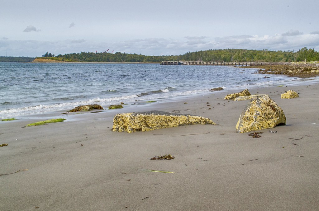
Beaches
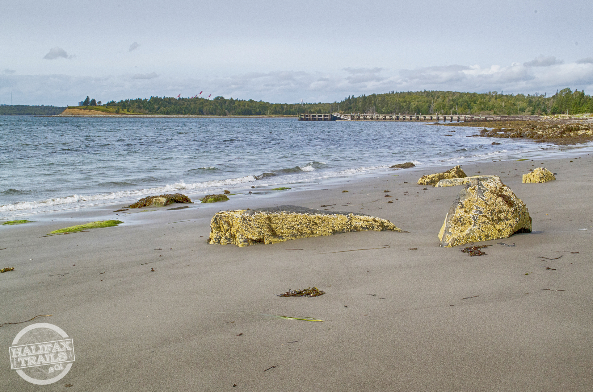 McNabs Island is absolutely stunning as a natural wonder. The island is full of spectacular wetlands, old mixed forests, rugged coastlines and sandy beaches. Naturalist heaven, the ecology of the island is diverse, unique, and breathtakingly beautiful. In Spring and Autumn, the island comes alive with colour, and in Summer the beautiful beaches are the city’s best hidden gems. The two main sandy beaches on the island are Wreck Cove on the calm, sheltered eastern side of the island and Maugers Beach on the open water western side of the island.
The island’s location at the mouth of Halifax Harbour makes it a sieve for garbage from the ocean and the harbour. Thanks to huge efforts by the Friends of McNabs Island Society who remove literal tons of garbage every year, these beaches are largely clean. To join the efforts every spring, stay tuned to their social media for updates.
A Family-Friendly Adventure
With something to please historians, naturalists and childhood imaginations alike, McNabs Island has something to appeal to everyone. The combination of history and nature made McNabs Island one of the most memorable local adventures of my childhood. Fond memories of exploring McNabs on school and family trips had a big part in shaping my appreciation for the great outdoors. The forts of Point Pleasant Park, York Redoubt & McNabs island are epic playgrounds for childhood imagination. Driftwood, beach rocks, rope, and other scavenged items are raw materials for natural arts and crafts that can keep children engaged and occupied on any length of trip.
If you’re looking for a fun, #family-friendly outdoor adventure McNabs Island Provincial Park, try “Treasure Island” to travel back in time and discover the hidden treasure on the island. The step-by-step instructions for this 5-6 km trail adventure and a route map can be downloaded at earthadventures.ca. The approximate time to complete the adventure is 5-6 hours.
McNabs Island Trip Tips
Windswept areas of the island are often very breezy compared to inland portions of the island. Weather on the mainland is not necessarily indicative of what to expect on the island, so you should be prepared for abrupt changes in temperature, wind, sudden fog & precipitation. Since you’re somewhat stuck on the island until your planned departure time, you’ll want to double-check to make sure you’re equipped to handle any weather possibility.
Keep in mind that camping is no longer allowed on McNabs Island, so an overnighter is not an option. The Department of Lands and Forestry regularly monitors the island and illegal camping comes with hefty fines.
Some items worth bringing include a soft cooler for group lunches and a hydration bladder for easy hydrating. Wear sturdy hiking footwear and always pack extra layers for warmth, wind & rain protection. A compact, quick-dry towel is handy if you’re intending to take a dip or to sit on the beach. A backpacking stove is a must if you intend to heat something up, as open fires are not allowed. Binoculars for birdwatching, boat traffic, or scoping out distant points of interest are also worth bringing. With plenty of benches, you don’t necessarily need to bring something to sit on, but I always find it handy to have a compact, lightweight sitting pad to enjoy those extra scenic spots that aren’t butt-friendly.
Cellphone reception on the island is a little spotty, so it’s best not to rely on your phone’s cellular data. Reception coming in and out also makes it a somewhat unreliable way to communicate with others in your group. While a GPS device isn’t necessary thanks to how well-marked everything is, it is definitely a help.
Tall grass throughout the island makes it important to be mindful of ticks whenever temperatures are above zero degrees. Ticks are now prevalent throughout the province, so it’s not a warning exclusive to McNabs Island. I didn’t encounter any on my trip but I’m always careful to stay on the trails and avoid contact as much as possible. I’ve created an in-depth tick-avoidance guide for reference here. Stay on the paths and try to get children and pets to do the same. Cover exposed skin, tuck shirts into pants, and pants into socks. Light-coloured clothes make them much easier to spot. Do quick tick checks at every stop, and finish your trip with a thorough check of your gear, yourself & pets when you arrive home.
SHOP.HALIFAXTRAILS.CA: Gear | Books | Sale

ATORPOK Camping Cot for Adults with Cushion Comfortable, Tent Folding Cot for Sleeping, Lightweight Folding Bed with Carry Ba...
$99.99 (as of 19:01 GMT -03:00 - More infoProduct prices and availability are accurate as of the date/time indicated and are subject to change. Any price and availability information displayed on [relevant Amazon Site(s), as applicable] at the time of purchase will apply to the purchase of this product.)
Anti-submarine net between Fort York Redoubt and McNabs Island, Halifax NS. May 1942.
https://amzn.to/4adpIsM


